Tennessee State Route 96
| ||||
|---|---|---|---|---|
 | ||||
| Route information | ||||
| Maintained by TDOT | ||||
| Length | 128.2 mi (206.3 km) | |||
| Major junctions | ||||
| West end |
| |||
|
| ||||
| East end |
| |||
| Location | ||||
| Counties | Dickson, Williamson, Davidson, Rutherford, Cannon, Wilson, DeKalb, Putnam, Smith, Jackson | |||
| Highway system | ||||
| ||||


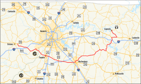
State Route 96 (SR 96) is an east–west highway in Middle Tennessee. The road begins in Dickson and ends in Granville. The current length is 128.2 mi (206.3 km).[1] Along its path it goes through 10 counties. Locals mostly refer to it as Highway 96.
Route Description
Dickson County
SR 96 begins as a primary highway in Dickson County in Dickson at an intersection with US 70/SR 1. It then goes southeast, leaving Dickson, before coming to an intersection with SR 47 in Burns. It then curves to the east and parallels I-40, passing just north of the I-40/I-840 interchange, before having an interchange with I-40 (Exit 182) just west of Fairview, just after crossing into Williamson County.
Williamson and Davidson Counties
SR 96 then enters Fairview and has a trumpet interchange and become concurrent with SR 100. They then go northeast and cross over the southern part of the Highland Rim just before crossing into the southwest corner of Davidson County. SR 96 then separates from SR 100 and then turns southeast to cross back into Williamson County. Just after crossing the county line, SR 96 has an interchange with the Natchez Trace Parkway, just after passing under the Natchez Trace Parkway Bridge. It then goes through some wooded areas before having an intersection with SR 46 just before entering Franklin. SR 96 then travels through some suburban areas before intersecting and becoming concurrent with US 31/US 431/SR 6/SR 106 in downtown. They first go south before turning east at an intersection with SR 246, which is also where US 431/SR 106 split off and continue south. SR 96 then splits off from US 31/SR 6 and goes east, leaving downtown and having an intersection with SR 397 and then an interchange with I-65 (Exit 65) before leaving Franklin and continuing southeast. SR 96 then passes through some farmland before passing through Arrington and having an intersection with SR 252. It then begins paralleling I-840 just before entering Triune, where it has an intersection with US 31A/SR 11, just north of its interchange with I-840 (Exit 42). SR 96 then goes east and crosses under the interstate before crossing into Rutherford County.
Rutherford County
It then almost immediately has an intersection with SR 102 just south of Almaville, which is also just south of its interchange with I-840 (Exit 47). SR 96 then leaves the interstate and passes through some rural countryside before entering Murfreesboro just before a partial cloverleaf interchange with I-24 (Exit 78). It then passes through a major retail district, passing by Stones River Mall and having an intersection and becoming concurrent with SR 99, before entering downtown and having an intersection with US 41/US 70S/US 231/SR 1/SR 10, with SR 96 curving to the northeast to become concurrent with US 231/SR 10 as they turn northeast at this intersection from the south. They go northeast, leaving downtown, for about a mile before SR 96 turns east onto E Clark Blvd. for a short distance before turning northeast again onto Lascassas Pike. SR 96 then has an intersection with SR 268 before it leaves Murfreesboro and continues northeast through countryside once more. It then passes through Lascassas and intersects and has a short concurrency with SR 266. SR 96 then curves to the east and passes through some more rural farmland and countryside, passing through Milton before crossing into northwest corner Cannon County.
Cannon and Wilson Counties
It then passes through Auburntown, where it has an intersection with SR 145 before crossing into the southeast corner of Wilson County. It then has an intersection with SR 267 just across the county line, south of Statesville, before passing through more countryside and then crossing into DeKalb County.
DeKalb County
It then comes to an intersection with US 70/SR 26/SR 53 near Liberty. They then enter Liberty at an intersection where SR 53 separates and turns south. They then pass through Liberty before leaving it to go east and pass through Dowelltown and some mountains before SR 96 separates from US 70/SR 26, just east of Smithville, as a very curvy secondary highway through some mountainous terrain. It then has an intersection with SR 264 before winding its way along the shores of Center Hill Lake before coming to an intersection with SR 141. They then become concurrent with each other and cross overtop Center Hill Dam together before separating with SR 96 turning north to cross into Putnam County.
Putnam and Smith Counties
It then immediately enters Buffalo Valley and has another interchange with I-40 (Exit 268). It then winds its through farmland, crossing briefly through the eastern portion of Smith County before crossing back into Putnam County, before coming to an intersection with and becoming concurrent with US 70N/SR 24 east of Chestnut Mound. They go east and wind through some more mountains before SR 96 splits off and goes north as an even curvier road before crossing into Jackson County.
Jackson County
SR 96 then runs along an arm of the Cordell Hull Lake/Cumberland River before entering Granville and ending at SR 53.
Major intersections
| County | Location | mi | km | Destinations | Notes |
|---|---|---|---|---|---|
| Dickson | Dickson | ||||
| 0.0 | 0.0 | Western terminus of SR 96 | |||
| Burns | |||||
| Williamson | New Hope | Exit 182 | |||
| Fairview | Interchange; Concurrency with SR 100 begins | ||||
| Davidson | Nashville | Concurrency with SR 100 ends | |||
| Williamson | Bingham | Via short access road | |||
| Franklin | Concurrency with US 431/SR 106 begins | ||||
| Concurrency with US 431/SR 106 ends; Concurrency with US 31/SR 6 begins | |||||
| Concurrency with US 31/SR 6 ends | |||||
| Exit 65 | |||||
| Arrington | |||||
| Triune | |||||
| Rutherford | Almaville | ||||
| Murfreesboro | Exit 78 | ||||
| Concurrency with SR 99 begins | |||||
| Concurrency with SR 99 ends; Concurrency with US 231/SR 10 begins | |||||
| Concurrency with US 231/SR 10 ends | |||||
| Compton | |||||
| Lascassas | Concurrency with SR 266 begins | ||||
| Concurrency with SR 266 ends | |||||
| Cannon | Auburntown | ||||
| Wilson | Prosperity | ||||
| DeKalb | Liberty | Unsigned concurrency with US 70/SR 26/SR 53 begins | |||
| Concurrency with SR 53 ends | |||||
| Dowelltown | Unsigned concurrency with US 70/SR 26 ends | ||||
| Temperance Hall | |||||
| Laurel Hill | Concurrency with SR 141 begins to cross Center Hill Dam | ||||
| Concurrency with SR 141 ends | |||||
| Putnam | Buffalo Valley | Exit 268 | |||
| Unsigned concurrency with US 70N/SR 24 begins | |||||
| Gentry | Unsigned concurrency with US 70N/SR 24 ends | ||||
| Jackson | Granville | 128.2 | 206.3 | Eastern terminus | |
1.000 mi = 1.609 km; 1.000 km = 0.621 mi
| |||||