U.S. Route 319
| |||||||||||||||||||
|---|---|---|---|---|---|---|---|---|---|---|---|---|---|---|---|---|---|---|---|
 | |||||||||||||||||||
| Route information | |||||||||||||||||||
| Auxiliary route of US 19 | |||||||||||||||||||
| Length | 303.052 mi[1][2] (487.715 km) | ||||||||||||||||||
| Existed | 1933–present | ||||||||||||||||||
| Major junctions | |||||||||||||||||||
| South end |
| ||||||||||||||||||
|
| |||||||||||||||||||
| North end |
| ||||||||||||||||||
| Location | |||||||||||||||||||
| States | Florida, Georgia | ||||||||||||||||||
| Highway system | |||||||||||||||||||
| |||||||||||||||||||

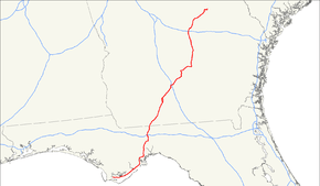
U.S. Route 319 (US 319) is a spur of U.S. Route 19. It runs for 303 miles (488 km) from the foot of the John Gorrie Memorial Bridge across from downtown Apalachicola, Florida to US 1/SR 4 in Wadley, Georgia, through the Panhandle of Florida and the southern portion of Georgia.
Route description
.svg.png)
Florida
The route starts as a two-lane highway at the eastern end of US 98's bridge over the Apalachicola River near the John Gorrie Bridge in Apalachicola, Florida, and is concurrent with US 98 from its starting point. After crossing the East Bay portion of Apalachicola Bay via the John Gorrie Bridge, US 319 runs along the Gulf coast of Florida's Panhandle to Carabelle in Franklin County, and departs the coast, and its concurrency with US 98, about halfway between Carrabelle and Bald Point State Park, in a north direction through Sopchoppy in Wakulla County.
In Sopchoppy, the route angles east, briefly meets up with US 98 once more, before parting ways again and running north through Crawfordville, where it receives the FDOT maintenance designation of State Road 369, into Tallahassee in Leon County. US 319 meets SR 61 just south of Tallahassee, marking the northern end of SR 369, where it becomes a 4-lane divided highway, which turns into 6 lanes as the route meets SR 263 and forms part of the southern and eastern portion of the Capital Circle around Tallahassee. US 319 has the unsigned SR 261 designation between State Road 363/Woodville Highway and Capital Circle's eastern terminus at State Road 61/Thomasville Road. US 319 crosses I-10, before heading northeast out of the Tallahassee area. US 319 again becomes a 4-lane divided highway at its intersection with County Road 0342 about 9 miles (14 km) from I-10, and runs to the state line with Georgia.
Georgia
The route enters Georgia's Grady County co-signed with SR 35, and travels northeast in the direction of Thomasville in Thomas County, where the route forms the western and northern perimeter around Thomasville. US 319 then continues northeast, passes through Coolidge, and crosses into Colquitt County, running as a bypass around the east of Moultrie. The route crosses into Tift County and intersects with I-75 just before running through Tifton.
In Ocilla, SR 35 comes to its northern terminus at an intersection with SR 32, which now becomes concurrent with US 319. Past Ocilla, the route, now co-signed with US 129, turns north and heads into Ben Hill County and through Fitzgerald, where it splits from US 129 and first heads east, and then north through the northwestern corner of Coffee County, where it meets up and is co-signed with US 441, and crosses the Ocmulgee River into Telfair County, Georgia at Jacksonville, Georgia and on into McRae-Helena. After briefly traversing the western corner of Wheeler County and eastern corner of Dodge County, US 319 continues north through Laurens County, crossing I-16 just before heading into and through Dublin and East Dublin, where US 441 splits off.
Continuing northeast, the route heads into Johnson County, runs through Wrightsville, and heads into southern Jefferson County, where it turns east in Bartow, before meeting its northern terminus at US 1 and SR 4 in Wadley.
US 319 from Tifton to the Florida State Line is a GRIP corridor.
History
Florida
The entire length of US 319 in Franklin County was designated as "Blue Star Memorial Highway" by the Florida State Legislature in 1957.[3]
The section of US 319 that is co-signed with US 98 and SR 30 in Medart in Wakulla County was designated as "Agnes Morrison Memorial Highway" by the Florida State Legislature in 1961.[4]
From Kinhega Drive, about 9 miles (14 km) north of its intersection with I-10 in Leon County, to the Georgia state line, US 319 and SR 61 were designated as "Kate Ireland Parkway" by the Florida State Legislature in 1992.[5]
Georgia
US 319 does not make an appearance on Georgia road maps until October 1937, when the spur from the Florida state line to Thomasville is shown, co-signed with SR 3.[6] Prior to October 1937, US 19 appears as the designation of this section of the route.[7]
In July 1941, US 319 was extended from Thomasville, and ran through Moultrie, following what was signed as SR 35 at the time, to Cordele, co-signed with the current route taken by SR 33 from Moultrie.[8] Since late in 1946, US 319 follows its current route.[9]
The section of US 319 that forms the Thomasville Bypass was designated as "Will Watt Parkway" in 1996 after a prominent resident of Thomasville.[10]
The section of US 319 that forms the east bypass around Moultrie in Colquitt County was designated as "Veterans Parkway" in 2002.[11]
Major intersections
| State | County | Location | mi[1][2] | km | Destinations | Notes | |
|---|---|---|---|---|---|---|---|
| Florida | Franklin | Apalachicola | 0.000 | 0.000 | Southern terminus; base of John Gorrie Memorial Bridge over Apalachicola River | ||
| see US 98 (mile 177.980-209.555) | |||||||
| | 31.575 | 50.815 | Northern end of US 98/SR 30 concurrency; southern end of SR 377 concurrency | ||||
| | 36.811 | 59.242 | Western terminus of CR 370 | ||||
| Wakulla | | 38.029 | 61.202 | Southern terminus of CR 299 | |||
| Sopchoppy | 42.204 | 67.921 | Rose Street (CR 375 north) - Downtown Sopchoppy, Sanborn | Northern end of SR 377 concurrency; southern end of SR 375 concurrency | |||
| 42.908 | 69.054 | Western terminus of CR 372 | |||||
| Medart | 48.654 | 78.301 | Southern end of US 98/SR 30 and SR 61 concurrencies; northern end of SR 375 concurrency | ||||
| Tully | 50.119 | 80.659 | Northern terminus of CR 375 | ||||
| 50.213 | 80.810 | Northern end of US 98/SR 30 concurrency | |||||
| | 54.659 | 87.965 | Harvey Mill Road (CR 374 west) | ||||
| Crawfordville | 55.394 | 89.148 | Arran Road (CR 368 west) | ||||
| 55.429 | 89.204 | Northern end of SR 61 concurrency; southern end of SR 369 concurrency; southern terminus of CR 61 | |||||
| | 61.516 | 99.000 | |||||
| Leon | | 66.187 | 106.518 | Western terminus of CR 2204 | |||
| | 68.469 | 110.190 | Northern end of SR 369 concurrency; southern end of SR 61 concurrency | ||||
| Tallahassee | 70.466 | 113.404 | Northern end of SR 61 concurrency; southern end of SR 263 concurrency | ||||
| 71.796 | 115.544 | Northern end of SR 263 concurrency; southern end of SR 261 concurrency | |||||
| 74.014 | 119.114 | ||||||
| 76.895 | 123.751 | Old St. Augustine Road (CR 2196) | |||||
| 77.404 | 124.570 | ||||||
| 79.668 | 128.213 | ||||||
| 80.370 | 129.343 | Eastern terminus of CR 146; western terminus of CR 0347 | |||||
| 81.066 | 130.463 | ||||||
| 82.781 | 133.223 | ||||||
| 82.89 | 133.40 | I-10 exit 203 | |||||
| 83.125 | 133.777 | Interchange southbound; intersection northbound | |||||
| 83.236 | 133.955 | Northern end of SR 261 concurrency; southern end of SR 61 concurrency; interchange southbound; intersection northbound | |||||
| 85.636 | 137.818 | Eastern terminus of CR 0346 | |||||
| Bradfordville | 87.465 | 140.761 | |||||
| Iamonia | 95.740 | 154.079 | Eastern terminus of CR 12 | ||||
| | 96.107 | 154.669 | Western terminus of CR 0338 | ||||
| 96.791 0.000 | 155.770 0.000 | Florida–Georgia state line; northern end of SR 61 concurrency; southern end of SR 35 concurrency | |||||
| Georgia | Grady | | 2.251 | 3.623 | Southern terminus of SR 93 | ||
| Thomas | Thomasville | Metcalf Road – Metcalf | Former SR 122 west | ||||
| | 17.023 | 27.396 | Southern end of US 84/SR 38 concurrency | ||||
| | Southern end of SR 3 Alt. concurrency | ||||||
| | 20.057 | 32.279 | Northern end of US 84/SR 38 and SR 3 Alt. concurrencies | ||||
| | Northern terminus of SR 35 Conn. | ||||||
| Coolidge | 31.375 | 50.493 | |||||
| Colquitt | Moultrie | 40.498 | 65.175 | Southern terminus of US 319 Bus. | |||
| 45.048 | 72.498 | Southern end of SR 37 and SR 133 concurrencies | |||||
| 45.788 | 73.689 | Northern end of SR 37 concurrency | |||||
| 47.578 | 76.569 | Northern end of SR 133 concurrency; northern terminus of US 319 Bus. | |||||
| Norman Park | 55.288 | 88.977 | Southern terminus of SR 256 | ||||
| Tift | | 65.487 | 105.391 | Old Omega Road east to I-75 – Valdosta, Macon | Western terminus of Old Omega Road | ||
| Tifton | 65.829 | 105.942 | Southern end of US 82/SR 520 concurrency | ||||
| 66.983 | 107.799 | ||||||
| | 68.383 | 110.052 | Northern end of US 82/SR 520 concurrency | ||||
| Irwin | Ocilla | 85.390 | 137.422 | Southern end of SR 32 concurrency | |||
| 85.941 | 138.309 | Northern terminus of SR 35; northern end of SR 32 and SR 35 concurrencies; southern end of US 129/SR 11/SR 90 concurrency | |||||
| Ben Hill | Fitzgerald | 96.960 | 156.042 | Northern end of US 129/SR 11/SR 90 concurrency; southern end of SR 107 concurrency | |||
| | 101.295 | 163.019 | Western terminus of SR 206 | ||||
| | 109.271 | 175.855 | Eastern terminus of SR 182 | ||||
| Coffee | | 116.473 | 187.445 | Northern end of SR 107 concurrency; southern end of US 441/SR 31 concurrency | |||
| Telfair | Jacksonville | 119.024 | 191.551 | ||||
| McRae-Helena | 138.086 | 222.228 | |||||
| 136.652 | 219.920 | ||||||
| 137.558 | 221.378 | Southern end of US 280/SR 30 concurrency | |||||
| 139.995 | 225.300 | Southern end of US 23/US 341/SR 27 concurrency | |||||
| Wheeler | 140.502 | 226.116 | Northern end of US 280/SR 30 concurrency | ||||
| Laurens | | 152.633 | 245.639 | ||||
| | 164.933 | 265.434 | Southern end of SR 117 concurrency | ||||
| Dublin | 169.265 | 272.406 | I-16 exit 51 | ||||
| 170.218 | 273.939 | Northern end of US 441 and SR 117 concurrencies; southern terminus of US 441 Byp. | |||||
| 172.456 | 277.541 | ||||||
| 173.306 | 278.909 | Western end of US 80/SR 26 concurrency | |||||
| East Dublin | 175.544 | 282.511 | Eastern end of US 80/SR 26 concurrency | ||||
| Johnson | Wrightsville | 182.604 | 293.873 | Northern end of SR 31 concurrency; southern end of SR 78 concurrency | |||
| Jefferson | | 197.940 | 318.554 | Southern end of US 221/SR 171 concurrency | |||
| Bartow | 201.176 | 323.761 | |||||
| 201.534 | 324.338 | Northern end of US 221/SR 171 concurrency | |||||
| Wadley | 205.707 | 331.053 | |||||
| 206.261 | 331.945 | Northern terminus; northern end of SR 78 concurrency | |||||
1.000 mi = 1.609 km; 1.000 km = 0.621 mi
| |||||||
Special routes
Thomasville connector
| |
|---|---|
| Location | Thomasville |
| Length | 1.2 mi[12] (1.9 km) |
State Route 35 Connector (SR 35 Conn.) is a 1.2-mile-long (1.9 km) connector route for SR 35 in the northeastern part of the Thomasville area. Its southern terminus is at US 19, US 84, SR 3, SR 38, and SR 300 in the northeastern part of Thomasville. Its northern terminus is at US 319/SR 35 northeast of the city. This highway used to be US 319 Bus./SR 35 Bus. in Thomasville.
The entire route is in Thomas County.
| Location | mi[12] | km | Destinations | Notes | |
|---|---|---|---|---|---|
| Thomasville | 0.0 | 0.0 | Southern terminus | ||
| | 1.2 | 1.9 | Northern terminus | ||
| 1.000 mi = 1.609 km; 1.000 km = 0.621 mi | |||||
Former Thomasville business route
| |
|---|---|
| Location | Thomasville |
| Existed | ?–2007 |
State Route 35 Business (SR 35 BUS) served the downtown area of Thomasville. The route was decommissioned in 2007.
Gallery
 US 319/SR 61 concurrency near the Georgia state line
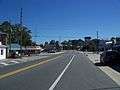 US 98/US 319 concurrency in Carrabelle
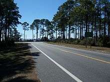 Intersection of SR 65 with US 98/319
 US 98/319 concurrency in Franklin County, Florida
See also
References
- 1 2 FDOT straight line diagrams, accessed February 2014
- 1 2 "County GIS Base map shapefiles/geodatabases (varies by county)". Georgia Department of Transportation. Retrieved 2012-12-11.
- ↑ Florida State Legislature (October 29, 1957). "Blue Star Memorial Highway Designation" (PDF). 57-2011. Retrieved 2012-12-11.
- ↑ Florida State Legislature (May 30, 1961). "Agnes Morrison Memorial Highway Designation" (PDF). 92-330. Retrieved 2012-12-11.
- ↑ Florida State Legislature (June 1, 1992). "Kate Ireland Parkway Designation" (PDF). 92-330. Retrieved 2012-12-11.
- ↑ Staff. State of Georgia System of State Roads (PDF) (Map) (October 1, 1937 ed.). Georgia State Highway Board. Retrieved 2012-12-11.
- ↑ Staff. State of Georgia System of State Roads (PDF) (Map) (July 1, 1937 ed.). Georgia State Highway Board. Retrieved 2012-12-11.
- ↑ Staff. State of Georgia System of State Roads (PDF) (Map) (July 1, 1941 ed.). Georgia State Highway Board. Retrieved 2012-12-11.
- ↑ Staff. State of Georgia System of State Roads (PDF) (Map) (November 7, 1946 ed.). Georgia State Highway Board. Retrieved 2012-12-11.
- ↑ Georgia General Assembly (November 21, 1996). "Will Watt Parkway — Designated" (PDF). Acts and Resolutions of the General Assembly of the State of Georgia 1996. Retrieved 2012-12-11.
- ↑ Georgia General Assembly (November 2002). "HR 838" (PDF). Acts and Resolutions of the General Assembly of the State of Georgia 2002. Retrieved 2012-12-11.
- 1 2 Google (March 3, 2017). "Overview map of SR 35 Conn." (Map). Google Maps. Google. Retrieved March 3, 2017.
External links
Route map: