Adrian, Georgia
| Adrian, Georgia | |
|---|---|
| City | |
 Location in Emanuel County and the state of Georgia | |
| Coordinates: 32°31′55″N 82°35′26″W / 32.53194°N 82.59056°WCoordinates: 32°31′55″N 82°35′26″W / 32.53194°N 82.59056°W | |
| Country | United States |
| State | Georgia |
| Counties | Johnson, Emanuel |
| Area | |
| • Total | 1.42 sq mi (3.68 km2) |
| • Land | 1.37 sq mi (3.56 km2) |
| • Water | 0.04 sq mi (0.11 km2) |
| Elevation | 286 ft (87 m) |
| Population (2010) | |
| • Total | 664 |
| • Estimate (2016)[1] | 651 |
| • Density | 483/sq mi (186.5/km2) |
| Time zone | UTC-5 (Eastern (EST)) |
| • Summer (DST) | UTC-4 (EDT) |
| ZIP code | 31002 |
| Area code(s) | 478 |
| FIPS code | 13-00660[2] |
| GNIS feature ID | 0310411[3] |
Adrian is a city in the U.S. state of Georgia, in Emanuel and Johnson counties. As of the 2010 census, the city had a population of 664.[4]
The Johnson County portion of Adrian is part of the Dublin Micropolitan Statistical Area.
History
A post office has been in operation at Adrian since 1891.[5] Adrian incorporated in 1899.[6] It is unknown why the name "Adrian" was applied to this community.[7]
Geography
Adrian is located at 32°31′55″N 82°35′26″W / 32.53194°N 82.59056°W (32.531960, -82.590680),[8] at the intersection of U.S. Route 80/Georgia State Route 26 with State Routes 15/78. US 80 leads east 16 miles (26 km) to Swainsboro and west 19 miles (31 km) to Dublin, while Routes 15 and 78 lead south 7 miles (11 km) to Interstate 16 and northwest 17 miles (27 km) to Wrightsville.
According to the United States Census Bureau, Adrian has a total area of 1.4 square miles (3.7 km2), of which 1.4 square miles (3.6 km2) is land and 0.04 square miles (0.1 km2), or 3.12%, is water.[9]
Demographics
| Historical population | |||
|---|---|---|---|
| Census | Pop. | %± | |
| 1900 | 833 | — | |
| 1910 | 816 | −2.0% | |
| 1920 | 740 | −9.3% | |
| 1930 | 685 | −7.4% | |
| 1940 | 580 | −15.3% | |
| 1950 | 503 | −13.3% | |
| 1960 | 568 | 12.9% | |
| 1970 | 705 | 24.1% | |
| 1980 | 756 | 7.2% | |
| 1990 | 615 | −18.7% | |
| 2000 | 579 | −5.9% | |
| 2010 | 664 | 14.7% | |
| Est. 2016 | 651 | [1] | −2.0% |
| U.S. Decennial Census[10] | |||
As of the census[2] of 2010, there were 558 people, 230 households, and 163 families residing in the city. The population density was 419.3 people per square mile (162.0/km²). There were 276 housing units at an average density of 199.9 per square mile (77.2/km²). The racial makeup of the city was 69.08% White, 30.57% African American, 0.17% Native American, 0.17% from other races. Hispanic or Latino of any race were 0.69% of the population.
There were 230 households out of which 29.1% had children under the age of 18 living with them, 47.4% were married couples living together, 19.6% had a female householder with no husband present, and 29.1% were non-families. 26.5% of all households were made up of individuals and 14.3% had someone living alone who was 65 years of age or older. The average household size was 2.52 and the average family size was 3.06.
In the city, the population was spread out with 28.0% under the age of 18, 7.1% from 18 to 24, 26.6% from 25 to 44, 20.6% from 45 to 64, and 17.8% who were 65 years of age or older. The median age was 36 years. For every 100 females, there were 81.5 males. For every 100 females age 18 and over, there were 73.0 males.
The median income for a household in the city was $18,281, and the median income for a family was $28,750. Males had a median income of $26,607 versus $21,071 for females. The per capita income for the city was $11,359. About 21.4% of families and 28.2% of the population were below the poverty line, including 46.1% of those under age 18 and 21.7% of those age 65 or over.
Notable person
- Izola Curry, assailant who tried to kill Martin Luther King, Jr., was born in Adrian.[11]
References
- 1 2 "Population and Housing Unit Estimates". Retrieved June 9, 2017.
- 1 2 "American FactFinder". United States Census Bureau. Archived from the original on 2013-09-11. Retrieved 2008-01-31.
- ↑ "US Board on Geographic Names". United States Geological Survey. 2007-10-25. Retrieved 2008-01-31.
- ↑ http://factfinder2.census.gov/faces/tableservices/jsf/pages/productview.xhtml?pid=DEC_10_SF1_GCTP2.ST13&prodType=table
- ↑ "Post Offices". Jim Forte Postal History. Retrieved 31 March 2018.
- ↑ "Adrian". GeorgiaGov. Retrieved 31 March 2018.
- ↑ Krakow, Kenneth K. (1975). Georgia Place-Names: Their History and Origins (PDF). Macon, GA: Winship Press. p. 2. ISBN 0-915430-00-2.
- ↑ "US Gazetteer files: 2010, 2000, and 1990". United States Census Bureau. 2011-02-12. Retrieved 2011-04-23.
- ↑ "Geographic Identifiers: 2010 Demographic Profile Data (G001): Adrian city, Georgia". American Factfinder. U.S. Census Bureau. Retrieved January 26, 2016.
- ↑ "Census of Population and Housing". Census.gov. Archived from the original on May 12, 2015. Retrieved June 4, 2015.
- ↑ Cold Case, Izola Ware Curry
Municipalities and communities of Emanuel County, Georgia, United States | ||
|---|---|---|
| Cities | 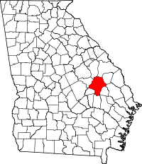 | |
| CDPs | ||
| Unincorporated communities | ||
| Footnotes | ‡This populated place also has portions in an adjacent county or counties | |
Municipalities and communities of Johnson County, Georgia, United States | ||
|---|---|---|
| Cities | 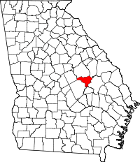 | |
| Footnotes | ‡This populated place also has portions in an adjacent county or counties | |