Texas State Highway 31
| ||||
|---|---|---|---|---|
 | ||||
| Route information | ||||
| Maintained by TxDOT | ||||
| Length | 143.3 mi[1] (230.6 km) | |||
| Existed | 1919–present | |||
| Major junctions | ||||
| West end |
| |||
|
| ||||
| East end |
| |||
| Location | ||||
| Counties | McLennan, Hill, Navarro, Henderson, Smith, Gregg | |||
| Highway system | ||||
| ||||

.jpg)
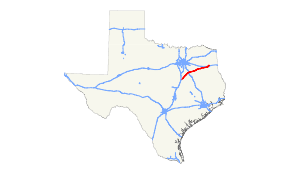
State Highway 31, or SH 31, runs from U.S. Highway 84 northeast of Waco via Corsicana, Athens, Tyler, Kilgore to U.S. Highway 80 in Longview.
History

SH 31 was a route proposed on October 9, 1917 to run from Waco northeast via Corsicana and Athens to Tyler, which remains the western portion of its current route to this day.[2] By 1926, the route had been extended northeast to Gladewater. On October 26, 1932, SH 31 Spur was designated through Malakoff.[3] On September 26, 1939, this extension was reassigned to U.S. Highway 271 (which it had been cosigned with earlier), with SH 31 now being extended east to Kilgore over former SH 176. SH 31 Spur was renumbered as Spur 63. On June 30, 1971, SH 31 extended north to I-20 concurrent with US 259. When U.S. Highway 259 was rerouted on July 25, 1985, SH 31 was extended northeast into Longview.
Major intersections
| County | Location | mi | km | Destinations | Notes |
|---|---|---|---|---|---|
| McLennan | | ||||
| | |||||
| | |||||
| | |||||
| Hill | Mount Calm | West end of FM 339 overlap | |||
| East end of FM 339 overlap | |||||
| | |||||
| Hubbard | |||||
| Navarro | | ||||
| Dawson | West end of FM 709 overlap | ||||
| East end of FM 709 overlap | |||||
| | |||||
| | West end of FM 55 overlap | ||||
| | East end of FM 55 overlap | ||||
| | |||||
| | |||||
| Corsicana | |||||
| Interchange | |||||
| I-45 exit 231; interchange. | |||||
| | |||||
| Powell | |||||
| | |||||
| Kerens | |||||
| | |||||
| Henderson | Trinidad | ||||
| Malakoff | |||||
| | |||||
| Athens | Interchange, west end of SL 7 overlap | ||||
| Interchange, west end of US 175 overlap | |||||
| Interchange, west end of SH 19 overlap | |||||
| Interchange, east end of SL 7, US 175, and SH 19 overlaps | |||||
| Murchison | |||||
| | West end of FM 1803 overlap | ||||
| | East end of FM 1803 overlap | ||||
| Brownsboro | |||||
| Former routing of TX 31 | |||||
| | |||||
| Chandler | |||||
| Smith | | ||||
| | |||||
| | |||||
| | |||||
| Tyler | |||||
| Saunders Ave | Interchange | ||||
| Fleishel Ave | Interchange | ||||
| | West end of FM 850 overlap | ||||
| | East end of FM 850 overlap | ||||
| | |||||
| | |||||
| Gregg | | ||||
| | |||||
| | |||||
| | |||||
| Kilgore | Interchange | ||||
| West end of US 259 Bus. overlap | |||||
| Interchange, east end of US 259 Bus. overlap, west end of US 259 overlap | |||||
| | I-20 exit 589 westbound, 589A-B eastbound; interchange, east end of US 259 overlap. | ||||
| | |||||
| | Interchange | ||||
| Longview | |||||
| 1.000 mi = 1.609 km; 1.000 km = 0.621 mi | |||||
References
- ↑ Transportation Planning and Programming Division (n.d.). "State Highway No. 31". Highway Designation Files. Texas Department of Transportation. Retrieved 2010-10-30.
- ↑ (PDF) https://publicdocs.txdot.gov/minord/MinuteOrderDocLib/003676754.pdf. Missing or empty
|title=(help) - ↑ (PDF) https://publicdocs.txdot.gov/minord/MinuteOrderDocLib/003673818.pdf. Missing or empty
|title=(help)