Sărmășag
| Sărmășag Sarmaság | |
|---|---|
| Commune | |
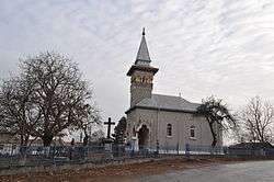 St. Nicholas Church in Moiad | |
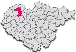 Location in Sălaj County | |
 Sărmășag Location in Romania | |
| Coordinates: 47°21′34″N 22°49′12″E / 47.35944°N 22.82000°E | |
| Country |
|
| County |
|
| Commune | Sărmășag |
| Historic region | Transylvania |
| Government | |
| • Mayor | Dombi Attila-János (Democratic Union of Hungarians in Romania) |
| Area | |
| • Total | 58.62 km2 (22.63 sq mi) |
| Population (2002) | |
| • Total | 6,547 |
| Time zone | UTC+2 (EET) |
| • Summer (DST) | UTC+3 (EEST) |
| Website | www.sarmasag.ro |
Sărmășag (Romanian: Sărmășag; Hungarian: Sarmaság) is a commune in Sălaj County, Transylvania, Romania.
Geography and climate
The commune's altitude is low, between 160m and 379m. The climate is continental, the average temperature in January is -3 °C, in July 21.1 °C. The average annually precipitation is about 627mm. The most important fossil fuel is the area is coal. The commune is composed of six villages: Ilișua (Selymesilosva), Lompirt (Szilágylompért), Moiad (Mojád), Poiana Măgura (Magurahegy), Sărmășag and Țărmure (Parttanya).
History
Sărmășag was already inhabited in the Iron Age. The first written documents date back to 1355. The name of the locality probably comes from László Sarmassághy who received the town from the Báthory family .
Demographics
As of the census of 2002 there were 6,547 people residing in the town.
The ethnic makeup of the commune was 5,168 Hungarians, 1,156 Romanians, 217 Romani, 4 Ukrainians, and one German.
Religious beliefs:
- Reformed - 4,635
- Romanian Orthodox - 1,164
- Roman Catholic - 426
- Baptist - 232
- Greek Catholic - 25
- Pentecostal - 13
- Evangelical - 2
Sights
- Reformed Church in Lompirt (built in the 18th century)
- Reformed Church in Ilișua (built in the 15th century)[1]
- St. Nicholas Church in Moiad (c.1936)
Sister cities
Coordinates: 47°21′N 22°50′E / 47.350°N 22.833°E
References
- ↑ welcometoromania.ro - Ilișua, Sălaj County, Reformed Church, retrieved on May 3, 2012