Søo
| Søo Søa | |
|---|---|
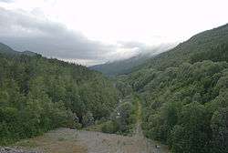 The Søo seen from the dam at the west end of Lake Vasslivatnet | |
 Location of the river  Søo (Norway) | |
| Country | Norway |
| County | Trøndelag |
| Municipality | Hemne |
| Physical characteristics | |
| Main source |
Lake Søvatnet Hemne, Orkdal, Rindal 270 metres (890 ft) 63°13′24″N 09°18′32″E / 63.22333°N 9.30889°E |
| River mouth |
Hemnfjorden Kyrksæterøra, Hemne 0 metres (0 ft) 63°17′38″N 09°05′19″E / 63.29389°N 9.08861°ECoordinates: 63°17′38″N 09°05′19″E / 63.29389°N 9.08861°E |
| Length | 30 km (19 mi) |
| Basin features | |
| Basin size | 237.93 km2 (91.87 sq mi) |
The Søo or Søa is a river in the municipality of Hemne in Trøndelag county, Norway.[1] The 30-kilometer (19 mi) long river originates at Lake Søo (Søvatnet), which lies on the municipal and county border of Orkdal and Hemne (in Trøndelag) and Rindal (in Møre og Romsdal county). The lake sits at an elevation of 280 meters (920 ft). It then flows into Lake Vassli (Vasslivatnet), which sits at roughly the same elevation, depending on levels behind the dam. The inflow to the Søo is regulated by a dam 20 meters (66 ft) high at the west end of Lake Vassli, which serves as a regulation reservoir for the Søa Hydroelectric Power Station.[2]
Its course flows from Lake Vassli through the Søo Valley (Søvassdalen) parallel to European route E39 highway. Further down towards the village of Vinjeøra, it turns northward about 2 kilometers (1.2 mi) east of the village. Norwegian County Road 680 follows the river northwards as flows into Lake Ro (Rovatnet; 13 meters or 43 feet). As the water exits the lake, it proceeds about 2 kilometers (1.2 mi) to the east through the village of Kyrksæterøra before it empties into in the Hemnfjorden.[1]
References
- 1 2 Haugen, Morten, ed. (2009-11-26). "Søa". Store norske leksikon (in Norwegian). Kunnskapsforlaget. Retrieved 2018-02-11.
- ↑ Rosvold, Knut A., ed. (2013-09-08). "Søa kraftverk". Store norske leksikon (in Norwegian). Kunnskapsforlaget. Retrieved 2018-02-11.