Rybníček (Vyškov District)
| Rybníček | |||
|---|---|---|---|
| Municipality | |||
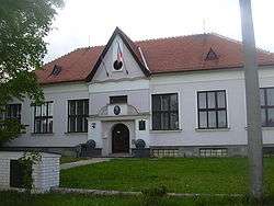 Municipal office | |||
| |||
 Rybníček | |||
| Coordinates: 49°16′20″N 17°4′27″E / 49.27222°N 17.07417°ECoordinates: 49°16′20″N 17°4′27″E / 49.27222°N 17.07417°E | |||
| Country |
| ||
| Region | South Moravian | ||
| District | Vyškov | ||
| Area | |||
| • Total | 2.1 km2 (0.8 sq mi) | ||
| Elevation | 236 m (774 ft) | ||
| Population (2006) | |||
| • Total | 274 | ||
| • Density | 130/km2 (340/sq mi) | ||
| Postal code | 682 01 | ||
| Website | http://www.obec-rybnicek.cz/ | ||

.svg.png)
Rybníček is a village and municipality (obec) in Vyškov District in the South Moravian Region of the Czech Republic.
The municipality covers an area of 2.1 square kilometres (0.81 sq mi), and has a population of 274 (as at 3 July 2006).
Rybníček lies approximately 6 kilometres (4 mi) east of Vyškov, 35 km (22 mi) east of Brno, and 212 km (132 mi) south-east of Prague.
References
| Wikimedia Commons has media related to Rybníček (Vyškov District). |
This article is issued from
Wikipedia.
The text is licensed under Creative Commons - Attribution - Sharealike.
Additional terms may apply for the media files.