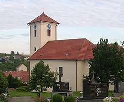
Nížkovice
| Nížkovice | |||
|---|---|---|---|
| Municipality | |||
 | |||
| |||
 Nížkovice | |||
| Coordinates: 49°6′40″N 16°54′1″E / 49.11111°N 16.90028°ECoordinates: 49°6′40″N 16°54′1″E / 49.11111°N 16.90028°E | |||
| Country |
| ||
| Region | South Moravian | ||
| District | Vyškov | ||
| Area | |||
| • Total | 7.02 km2 (2.71 sq mi) | ||
| Elevation | 260 m (850 ft) | ||
| Population (1.1.2012) | |||
| • Total | 673 | ||
| • Density | 96/km2 (250/sq mi) | ||
| Postal code | 683 56 | ||
| Website | http://www.nizkovice.cz | ||
Nížkovice is a village and municipality (obec) in Vyškov District in the South Moravian Region of the Czech Republic.
The municipality covers an area of 7.02 square kilometres (2.71 sq mi), and has a population of 654 (as at 3 July 2006).
Nížkovice lies approximately 19 kilometres (12 mi) south of Vyškov, 23 km (14 mi) south-east of Brno, and 210 km (130 mi) south-east of Prague.
References
| Wikimedia Commons has media related to Nížkovice. |
This article is issued from
Wikipedia.
The text is licensed under Creative Commons - Attribution - Sharealike.
Additional terms may apply for the media files.