Ruth Mountain
| Ruth Mountain | |
|---|---|
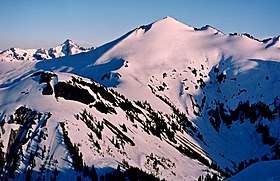 Ruth Mountain seen from Hannegan Peak | |
| Highest point | |
| Elevation | 7,115 ft (2,169 m) [1] |
| Prominence | 1,315 ft (401 m) [1] |
| Coordinates | 48°51′35″N 121°31′58″W / 48.859798°N 121.532872°WCoordinates: 48°51′35″N 121°31′58″W / 48.859798°N 121.532872°W [1] |
| Geography | |
 Ruth Mountain  Ruth Mountain Ruth Mountain (the US) | |
| Parent range | North Cascades |
| Topo map | USGS Mount Shuksan |
| Climbing | |
| First ascent | 1916[2] |
| Easiest route | Scramble |
Ruth Mountain is a Skagit Range summit located two miles south of Hannegan Pass in the North Cascades of Washington state. The name honors Ruth Cleveland, daughter of President Grover Cleveland.[2] Ruth Mountain is situated on the shared border of North Cascades National Park and the Mount Baker Wilderness (which is part of the Mount Baker-Snoqualmie National Forest). The summit offers views of Mount Shuksan, East Nooksack Glacier, Seahpo Peak, Nooksack Tower, Icy Peak, Mount Sefrit, and the Picket Range. The melting and receding Ruth Glacier on the north slope of Ruth creates the headwaters for the Chilliwack River. Precipitation runoff also finds its way into the Nooksack River.
Climate
Ruth Mountain is located in the marine west coast climate zone of western North America.[2] Most weather fronts originate in the Pacific Ocean, and travel northeast toward the Cascade Mountains. As fronts approach the North Cascades, they are forced upward by the peaks of the Cascade Range, causing them to drop their moisture in the form of rain or snowfall onto the Cascades. As a result, the west side of the North Cascades experiences high precipitation, especially during the winter months in the form of snowfall. During winter months, weather is usually cloudy, but, due to high pressure systems over the Pacific Ocean that intensify during summer months, there is often little or no cloud cover during the summer.[2] Because of maritime influence, snow tends to be wet and heavy, resulting in high avalanche danger.[2]
Geology
The North Cascades features some of the most rugged topography in the Cascade Range with craggy peaks, ridges, and deep glacial valleys. Geological events occurring many years ago created the diverse topography and drastic elevation changes over the Cascade Range leading to the various climate differences. These climate differences lead to vegetation variety defining the ecoregions in this area.
The history of the formation of the Cascade Mountains dates back millions of years ago to the late Eocene Epoch.[3] With the North American Plate overriding the Pacific Plate, episodes of volcanic igneous activity persisted.[3] In addition, small fragments of the oceanic and continental lithosphere called terranes created the North Cascades about 50 million years ago.[3]
During the Pleistocene period dating back over two million years ago, glaciation advancing and retreating repeatedly scoured the landscape leaving deposits of rock debris.[3] The “U”-shaped cross section of the river valleys are a result of recent glaciation. Uplift and faulting in combination with glaciation have been the dominant processes which have created the tall peaks and deep valleys of the North Cascades area.
References
- 1 2 3 "Ruth Mountain, Washington". Peakbagger.com.
- 1 2 3 4 5 Beckey, Fred W. (2008). Cascade Alpine Guide, Vol. 3, Rainy Pass to Fraser River (3rd ed.). Mountaineers Books. ISBN 1-59485-136-0.
- 1 2 3 4 Kruckeberg, Arthur (1991). The Natural History of Puget Sound Country. University of Washington Press.
External links
- Mt. Baker Wilderness U.S. Forest Service