Ruth Glacier
| Ruth Glacier | |
|---|---|
 Ruth Glacier | |
| Type | Valley glacier |
| Location | Matanuska-Susitna Borough, Alaska, U.S. |
| Coordinates | 62°45′55″N 150°37′42″W / 62.76528°N 150.62833°WCoordinates: 62°45′55″N 150°37′42″W / 62.76528°N 150.62833°W |
| Length | 40 miles (64 km) |
| Thickness | 3,800 feet (1,200 m) (1983) |
| Terminus | moraine |
| Status | unknown |
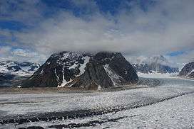
Ruth Glacier is a glacier in Denali National Park and Preserve in the U.S. state of Alaska.[1] Its upper reaches are approximately 4.8 vertical kilometers below the summit of Denali. The glacier's "Great Gorge" is 1.6 kilometers wide, and drops almost 610 meters over 16 kilometers, with crevasses along the surface. Above the surface on both sides are 1500 meter granite cliffs. From the top of the cliffs to the bottom of the glacier is a height exceeding that of the Grand Canyon. Ruth Glacier moves at a rate of 1 meter per day and was measured to be 1200 meters thick in 1983.[2]
Surrounding the Ruth Gorge are many mountains of the Alaska Range, including the Mooses Tooth, with highly technical ice and rock climbs on their faces.
History
In 1903, the glacier was explored by physician and ethnographer Frederick Cook, who named it after his youngest daughter.[3][4]
See also
Cited references
- ↑ "USGS Talkeetna D-2 (AK) Topo Map". Topozone. Retrieved 2007-01-25.
- ↑ "Ruth Glacier". Denali National Park and Preserve. National Park Service. Retrieved 2007-01-25.
- ↑ "Ruth and Helene Cook". Haeckel Collection. Getty Images. Retrieved 2018-09-26.
- ↑ "Ruth Glacier". Geographic Names Information System. United States Geological Survey. Retrieved 2018-09-26.
| Wikimedia Commons has media related to Ruth Glacier. |