Mount Shuksan
| Mount Shuksan | |
|---|---|
 Mt Shuksan as seen from Baker Lake to the south | |
| Highest point | |
| Elevation | 9,131 ft (2,783 m) NGVD 29[1] |
| Prominence | 4,411 ft (1,344 m) [1] |
| Coordinates | 48°49′54″N 121°36′11″W / 48.8315495°N 121.603169886°WCoordinates: 48°49′54″N 121°36′11″W / 48.8315495°N 121.603169886°W [2] |
| Geography | |
| Location | Whatcom County, Washington, U.S. |
| Parent range | Cascades |
| Topo map | USGS Mount Shuksan |
| Geology | |
| Age of rock | Cretaceous |
| Mountain type | Metamorphic schist |
| Climbing | |
| First ascent | September 7, 1906 by Asahel Curtis and party |
| Easiest route | rock/ice climb, class 3[1] |
Mount Shuksan is a glaciated massif[3] in the North Cascades National Park. Shuksan rises in Whatcom County, Washington immediately to the east of Mount Baker, and 11.6 miles (18.7 km) south of the Canada–US border. The mountain's name Shuksan is derived from the Lummi word [šéqsən], said to mean "high peak".[4] The highest point on the mountain is a three sided peak known as Summit Pyramid.[5]
The mountain is composed of Shuksan greenschist, oceanic basalt that was metamorphosed when the Easton terrane collided with the west coast of North America, approximately 120 million years ago.[6] The mountain is an eroded remnant of a thrust plate formed by the Easton collision.[3]
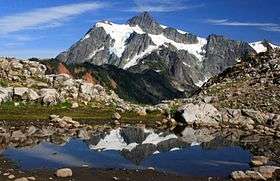
Mount Shuksan may be one of the most photographed mountains in the Cascade Range.[7] Photographs with its reflection in Picture Lake near Mount Baker Ski Area are particularly common. The Mount Baker Highway, State Route 542, is kept open during the winter to support the ski area; in late summer, the road to Artist Point allows visitors to travel a few miles higher for a closer view of the peak.
Sulphide Creek Falls, one of the tallest waterfalls in North America, plunges off the southeastern flank of Mount Shuksan. There are four other tall waterfalls that spill off Mount Shuksan and neighboring Jagged Ridge and Seahpo Peak, mostly sourced from small snowfields and glaciers.
The traditional name of Mount Shuksan in the Nooksack language is Shéqsan ("high foot") or Ch’ésqen ("golden eagle").[8]
The first ascent of Mount Shuksan is usually attributed to Asahel Curtis and W. Montelius Price on September 7, 1906. However, in a letter to the editor of the Mazamas club journal, C. E. Rusk attributed the first ascent to Joseph Morowits in 1897 and also stated that he would have attempted it in 1903 if he had not been sure that it had already been climbed.[9]
Nearby mountains

References
- 1 2 3 "Mount Shuksan, Washington". Peakbagger.com.
- ↑ "Mt Shuksan". NGS data sheet. U.S. National Geodetic Survey.
- 1 2 Tabor, R. W.; Haugerud, R. A. (1999). Geology of the North Cascades: a mountain mosaic. The Mountaineers. p. 92.
- ↑ Bright, William (2004). Native American placenames of the United States. University of Oklahoma Press. p. 441. ISBN 978-0-8061-3598-4.
- ↑ "Summit Pyramid". Geographic Names Information System. United States Geological Survey.
- ↑ "Terranes of the North Cascades". National Park Service.
- ↑ "Mount Shuksan". Cascade Classics.
- ↑ "Cultural Resources Department". NookSack Indian Tribe. Retrieved 2013-09-16.
- ↑ Curtis, Asahel (March 1907). "Ascent of Mount Shuksan". Mazama. Portland, OR: Mazamas. 3 (1): 27–29.
External links
| Wikimedia Commons has media related to Mount Shuksan. |
- "Mount Shuksan". Geographic Names Information System. United States Geological Survey.
- "Mount Shuksan". Peakware.com.
- "Mount Shucksan Views from Table Mountain Hike". Washingtonstatetours.com