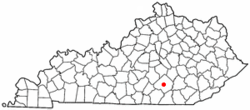
Ruth, Caldwell County, Kentucky
| Ruth | |
|---|---|
| Unincorporated community | |
 Ruth, Kentucky | |
 Ruth Location within the state of Kentucky  Ruth Ruth (the US) | |
| Coordinates: 37°6′31″N 87°44′55″W / 37.10861°N 87.74861°WCoordinates: 37°6′31″N 87°44′55″W / 37.10861°N 87.74861°W | |
| Country | United States |
| State | Kentucky |
| County | Caldwell |
| Elevation | 469 ft (143 m) |
| Time zone | UTC-6 (Central (CST)) |
| • Summer (DST) | UTC-5 (CST) |
| ZIP codes | 42501 |
| GNIS feature ID | 508990[1] |
Ruth is an unincorporated community and coal town in Caldwell County, Kentucky, United States. It is located 5 miles east from Somerset, Kentucky, near Daniel Boone National Forest.
References
Municipalities and communities of Caldwell County, Kentucky, United States | ||
|---|---|---|
| Cities | 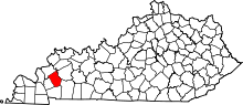 | |
| Unincorporated communities |
| |
| Footnotes | ‡This populated place also has portions in an adjacent county or counties | |
This article is issued from
Wikipedia.
The text is licensed under Creative Commons - Attribution - Sharealike.
Additional terms may apply for the media files.