Fryer, Kentucky
| Fryer | |
|---|---|
| Unincorporated community | |
 Fryer Location within the state of Kentucky  Fryer Fryer (the US) | |
| Coordinates: 37°15′44″N 87°49′11″W / 37.26222°N 87.81972°WCoordinates: 37°15′44″N 87°49′11″W / 37.26222°N 87.81972°W | |
| Country | United States |
| State | Kentucky |
| County | Caldwell |
| Elevation | 387 ft (118 m) |
| Time zone | UTC-6 (Central (CST)) |
| • Summer (DST) | UTC-5 (CST) |
| GNIS feature ID | 508049[1] |
Fryer is an unincorporated community in Caldwell County, Kentucky, United States. It was also known as The Hall, for a local Grange Hall.[2]
References
- ↑ U.S. Geological Survey Geographic Names Information System: Fryer, Kentucky
- ↑ Rennick, Robert M. (1987). Kentucky Place Names. University Press of Kentucky. p. 111. Retrieved 2013-04-28.
Municipalities and communities of Caldwell County, Kentucky, United States | ||
|---|---|---|
| Cities | 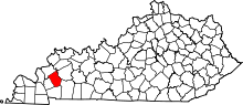 | |
| Unincorporated communities |
| |
| Footnotes | ‡This populated place also has portions in an adjacent county or counties | |
This article is issued from
Wikipedia.
The text is licensed under Creative Commons - Attribution - Sharealike.
Additional terms may apply for the media files.