Russellville Downtown Historic District
|
Russellville Downtown Historic District | |
 | |
  | |
| Location | Roughly bounded by W. 2nd St., Arkansas Ave., Missouri--Pacific RR tracks and El Paso St., Russellville, Arkansas |
|---|---|
| Coordinates | 35°16′44″N 93°8′6″W / 35.27889°N 93.13500°WCoordinates: 35°16′44″N 93°8′6″W / 35.27889°N 93.13500°W |
| Area | 19 acres (7.7 ha) |
| Built | 1875-1936 |
| Architect | H. Ray Burks, others |
| Architectural style | Early Commercial, other |
| NRHP reference # | 96000941[1] |
| Added to NRHP | September 3, 1996 |
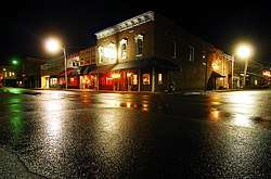
The Russellville Downtown Historic District encompasses an eight-block area of downtown Russellville, Arkansas. This area, developed primarily between 1875 and 1930, includes the city's highest concentration of period commercial architecture, a total of 34 buildings. Most of them are brick, one or two stories in height, and in a variety of styles. The district is roughly bounded by Arkansas and West 2nd Streets, El Paso Avenue, and the Missouri-Pacific Railroad tracks.[2]
The district was listed on the National Register of Historic Places in 1996.[1]
It includes:
- Pope County Courthouse (1931), 100 West Main Street, the "dominant" building in the district, a four story brick building designed by architect H. Ray Burks in Art Deco style[2]
- Riggs-Hamilton American Legion Post No. 20 (1936), built by Works Progress Administration, separately listed on the National Register[2]
- railroad depot, separately listed on the National Register[2]
See also
References
- 1 2 National Park Service (2010-07-09). "National Register Information System". National Register of Historic Places. National Park Service.
- 1 2 3 4 Sandra Taylor Smith (May 30, 1996). "National Register of Historic Places Inventory-nomination: Russellville Downtown Historic District" (PDF). Arkansas Preservation. Retrieved 2016-04-30.
| Topics | |
|---|---|
| Lists by states |
|
| Lists by insular areas | |
| Lists by associated states | |
| Other areas | |
| |
This article is issued from
Wikipedia.
The text is licensed under Creative Commons - Attribution - Sharealike.
Additional terms may apply for the media files.