Rundle Street, Adelaide
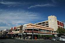
Rundle Street is a street in the East End of the city centre of Adelaide, the capital of South Australia. It runs from Pulteney Street in the west to East Terrace, where it becomes Rundle Road. (A separate Rundle Street continues from Rundle Road through Kent Town).[1] Its former western extent, which ran to King William Street, was closed in 1972 to form the pedestrian street of Rundle Mall. The street is in proximity to the Adelaide Botanic Gardens, Rymill Park, Hindmarsh Square and North Terrace.
The street was named after John Rundle, a director of the South Australia Company and member of the British House of Commons, by the Street Naming Committee on 23 May 1837.[2] It was installed with the first electric street lighting in South Australia in 1895 at the former intersection of Rundle, King William and Hindley streets.
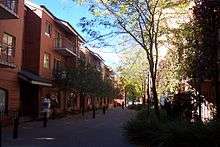
The street contains numerous cafés, restaurants, shops, cinemas, clubs and hotels. It is one of Adelaide's most popular streets for cafés and fashion. Most of the street has a heritage façade, but has been redeveloped for modern use, with some buildings converted to residences, such as the East End Markets.
The street is two-lane with parking on both sides plus bicycle lanes. A tramline ran through the street in the early 20th century. It is one of the narrower streets of the Adelaide grid, at 1 chain (66 ft; 20 m) wide.
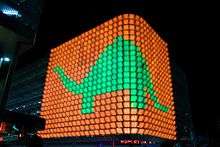
Rundle Lantern
In late 2006, the Adelaide City Council proposed to transform Rundle Street's western approach, the Pulteney Street-Rundle Mall junction, into a Piccadilly Circus or Times Square-type meeting place at a cost of around $1.5 million.[3] The proposal, based on ideas expressed in mid-2005 for neon billboards and video screens,[4] included an initial nine design concepts which were narrowed to two for consideration by the Council in early 2007.[5] A minimal design called the Rundle Lantern – a 748 panel LED lighting display wrapping around the façade of the Rundle Street carpark – was eventually selected, with the Council deciding video screens were inappropriate for the location.[6] The Rundle Lantern was designed and developed by the Fusion company, with the design strategy focused on creating a 'lantern' for the city to use as a dynamic cultural canvas. There has been controversy about crediting artists that have contributed to the lantern. [7]
Shop Listings
Fashion Alannah Hill, Zimmermann, Sass & Bide, Gorman, Saba, Marcs, Metalicus, Steve Madden Shoes, Sooki, Tu Yu Boutique, Botika Clothing, Miss Gladys Sym Choon, Bauhaus, Snow n' Surf Co, Das, Midwest Trader, Calibre, Jack London, Mimco, Morrison[8]
Eateries Felici Espresso, Cibo Espresso, Lemongrass Thai Bistro, Eros Cafe, San Giorgio Italian, Vego & Lovin' It, Joy Discovery, T2 Tea, Nano (via Ebenezer Place)
Night Life Distill, Mary's Poppin, Hacienda, Austral Hotel, The Stag Hotel, Sugar, Belgian Beer Cafe, The Stag Hotel, Exeter Hotel
Junction list
| Location | km[9] | mi | Destinations | Notes | |
|---|---|---|---|---|---|
| Adelaide city centre | 0 | 0.0 | Pulteney Street | Continues as Rundle Mall | |
| 0.2 | 0.12 | Frome Street | |||
| 0.5 | 0.31 | East Terrace | Continues as Rundle Road | ||
| 1.000 mi = 1.609 km; 1.000 km = 0.621 mi | |||||
See also
![]()
References
- ↑ 2003 Adelaide Street Directory, 41st Edition. UBD (A Division of Universal Press Pty Ltd). 2003. ISBN 0-7319-1441-4.
- ↑ "Rundle Mall" (PDF). Adelaide City Council. Retrieved 6 January 2006.
- ↑ Vlach, Anna. "Adelaide's Times Square", The Advertiser, 13 November 2006.
- ↑ Drayse, Rebecca. "Our Times Square", The City Messenger, 13 July 2005.
- ↑ Leo, Jessica. "Decision on Adelaide's Times Square", The Advertiser, 16 April 2007.
- ↑ Leo, Jessica. "Council votes for scaled 'Times Square'", The Advertiser, 16 April 2007.
- ↑ "Art: Adelaide artists get a raw deal when producing Rundle Lantern animations". Retrieved 15 January 2015.
- ↑ "Rundle Street East fashion stores". Retrieved 24 June 2013.
- ↑ Google (11 December 2016). "Rundle Street, Adelaide" (Map). Google Maps. Google. Retrieved 11 December 2016.
External links
- Created by Fusion Rundle Lantern
Coordinates: 34°55′21″S 138°36′20″E / 34.92249°S 138.605436°E
Streets and squares of Adelaide city centre | |||||||||||||
|---|---|---|---|---|---|---|---|---|---|---|---|---|---|
| |||||||||||||