Rowena, Kentucky
| Rowena | |
|---|---|
| Unincorporated community | |
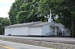 Baptist church on U.S. Route 127 | |
 Rowena Location within the state of Kentucky  Rowena Rowena (the US) | |
| Coordinates: 36°52′40″N 85°6′23″W / 36.87778°N 85.10639°WCoordinates: 36°52′40″N 85°6′23″W / 36.87778°N 85.10639°W | |
| Country | United States |
| State | Kentucky |
| County | Russell |
| Elevation | 981 ft (299 m) |
| Time zone | UTC-6 (Central (CST)) |
| • Summer (DST) | UTC-5 (EDT) |
| GNIS feature ID | 508982[1] |
Rowena is an unincorporated community located in Russell County, Kentucky, United States.
A post office called Rowena was established in 1847, and remained in operation until 1967.[2] The community most likely was named after a local woman.[3]
References
- ↑ U.S. Geological Survey Geographic Names Information System: Rowena, Kentucky
- ↑ "Russell County". Jim Forte Postal History. Retrieved 25 December 2015.
- ↑ Rennick, Robert M. Kentucky Place Names. University Press of Kentucky. p. 257. ISBN 0-8131-2631-2.
Municipalities and communities of Russell County, Kentucky, United States | ||
|---|---|---|
| Cities | 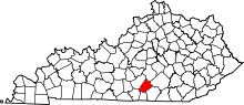 | |
| Unincorporated communities | ||
| Ghost town | ||
| Footnotes |
| |
This article is issued from
Wikipedia.
The text is licensed under Creative Commons - Attribution - Sharealike.
Additional terms may apply for the media files.