Japan National Route 41
| |
|---|---|
|
Yon-ichi, Shippin 国道41号 (Kokudō Yonjūichi-gō) | |
 | |
| Route information | |
| Length | 252.1 km (156.6 mi) |
| Existed | 1953 – present |
| Major junctions | |
| South end | Nagoya, Aichi Prefecture |
| North end | Toyama, Toyama Prefecture |
| Highway system | |
|
National highways of Japan Expressways of Japan | |

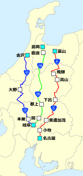
National Route 41 (国道41号 Kokudō Yonjūichi-gō) is a national highway connecting Nagoya, Aichi Prefecture, and Toyama, Toyama Prefecture, Japan. The bulk of the road run throughs Gifu Prefecture. The route is also referred to as Yon-ichi and Shippin, based on the Japanese readings for the route numbering.
The road generally follows the route of JR Central's Takayama Main Line, except for a few locations around the cities of Takayama and Hida. The northern part of the route is generally used for sightseeing and the southern part is for industry. As a result, the northern areas are generally crowded only on weekends and holidays, whereas the southern areas, especially around Nagoya, have high traffic volume every day.
Route data
Starting Point
- Length: 252.1 km (156.6 mi)
- Origin: Higashi-ku, Nagoya, Aichi Prefecture (originates at junction with Route 19)
- Terminus: Toyama, Toyama Prefecture (ends at junction with Route 8)
- Major cities: Minokamo, Gero, Takayama
History
Overlapping sections
Municipalities passed through
Intersects with
- Aichi Prefecture
- Route 19 (at the origin)
- Route 302 (Nagoya's Higashi-ku)
- Route 155 (Komaki)
- Gifu Prefecture
- Toyama Prefecture
| Wikimedia Commons has media related to Route 41 (Japan). |
This article is issued from
Wikipedia.
The text is licensed under Creative Commons - Attribution - Sharealike.
Additional terms may apply for the media files.