Rotterdam–The Hague metropolitan area
| Rotterdam-The Hague metropolitan area Metropoolregio Rotterdam Den Haag | |||
|---|---|---|---|
| Conurbation | |||
| Metropolitan region Rotterdam The Hague | |||
| |||
.svg.png) Location in the province of South Holland, Netherlands | |||
| Coordinates: 52°24′N 4°54′E / 52.400°N 4.900°ECoordinates: 52°24′N 4°54′E / 52.400°N 4.900°E | |||
| Country | Netherlands | ||
| Province | South Holland | ||
| Largest cities |
Rotterdam The Hague | ||
| Other municipalities |
Zoetermeer Westland Delft Nissewaard Schiedam Leidschendam-Voorburg Vlaardingen Capelle aan den IJssel | ||
| Area[1] | |||
| • Total | 1,130 km2 (440 sq mi) | ||
| • Land | 990 km2 (380 sq mi) | ||
| • Water | 140 km2 (50 sq mi) 8.01% | ||
| • Urban | 440 km2 (170 sq mi) | ||
| • Rural | 550 km2 (210 sq mi) | ||
| Highest elevation | 69 m (226 ft) | ||
| Lowest elevation | -6.76 m (−22.18 ft) | ||
| Population (2015)[1] | |||
| • Total | 2,200,000 | ||
| • Density | 2,250/km2 (5,800/sq mi) | ||
| • Urban density | 5,000/km2 (10,000/sq mi) | ||
| Website |
www | ||
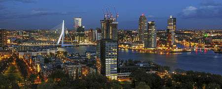

The Rotterdam–The Hague metropolitan area (Dutch: Metropoolregio Rotterdam Den Haag)[2] is a metropolitan area encompassing the cities of Rotterdam and The Hague as well as 21 other municipalities.[3] It finds its legal basis in law.[4] It was founded in 2014. The area has a population of over 2 million across 1,130 km2 (440 sq mi).[1] The largest European port and many international organizations reside within its borders.
The area is also part of the larger urban area called Randstad. Air traffic is supported by Rotterdam-The Hague Airport offering services to a number of European cities, however the majority of air travelers use Amsterdam Airport Schiphol, which is about 45 kilometers from The Hague. RandstadRail offers light rail public transport in the area and also Rotterdam metro, The Hague tram, Rotterdam tram and the frequent trains of the Dutch railways are popular modes for public transportation within the region.
Goal
The main reason for the cooperation is economic, to keep and make the area more attractive to international companies and organizations.
Economy
The area has two main cores, the cities of Rotterdam and The Hague. The city of Delft is situated in between the two major cities. The area has a GDP of 170 billion Euros. There are 2700 foreign companies.
Municipalities
| Municipality | Population | Total area [km2] |
|---|---|---|
| Rotterdam | 635389 | 325.79 |
| The Hague | 527748 | 98.12 |
| Zoetermeer | 124971 | 37.05 |
| Westland | 106752 | 90.58 |
| Delft | 101400 | 24.06 |
| Nissewaard | 84929 | 98.74 |
| Schiedam | 77920 | 19.86 |
| Leidschendam-Voorburg | 74788 | 35.62 |
| Vlaardingen | 71972 | 26.69 |
| Capelle aan den IJssel | 66712 | 15.40 |
| Lansingerland | 60904 | 56.37 |
| Pijnacker-Nootdorp | 53420 | 38.61 |
| Rijswijk | 51742 | 14.49 |
| Barendrecht | 48474 | 21.73 |
| Ridderkerk | 45743 | 25.26 |
| Hellevoetsluis | 38778 | 46.27 |
| Maassluis | 32493 | 10.12 |
| Krimpen aan den IJssel | 29120 | 8.95 |
| Wassenaar | 26101 | 62.37 |
| Albrandswaard | 25163 | 23.76 |
| Midden-Delfland | 19244 | 49.38 |
| Brielle | 16976 | 31.14 |
| Westvoorne | 14463 | 97.48 |
| Total | 2,279,459 | 1,257.84 |
References
- 1 2 3 Kerngetallen* MRDH, 2015, mrdh.nl
- ↑ Official website Metropolitan region Rotterdam The Hague: European Projects (Visited on 2018-05-14)
- ↑ http://www.mrdh.nl
- ↑ https://zoek.officielebekendmakingen.nl/gmb-2014-75363.html