Ross Embayment
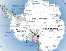
The Ross Embayment is a large region of Antarctica, comprising the Ross Ice Shelf and the Ross Sea.
Extent
The continent of Antarctica has two major divisions; West Antarctica in mostly west longitudes and East Antarctica in mostly east longitudes. East Antarctica is larger and has a higher average elevation. Separating the two subcontinents is a lower elevation topographic region occupied by the Ross Ice Shelf and the Ross Sea. This region is referred to as the Ross Embayment. The embayment comprises an area of approximately 1,137,000 square kilometres (439,000 sq mi). It includes the Ross Sea (637,000 square kilometres (246,000 sq mi))[1] and the Ross Ice Shelf (as of 2013, 500,809 square kilometres (193,363 sq mi)).[2] The name is most commonly used in the scientific literature,[3][4][5] at times along with the West Antarctic Rift System, which is of larger extent and has geologic meaning.[6]
The more informal use of the name 'Ross Embayment' tends to denote a smaller region, extending from Northern Victoria Land and the Transantarctic Mountains on the west (in East Antarctica) to the Edward VII Peninsula, Shirase Coast and Siple Coast on the east (Marie Byrd Land in West Antarctica), and south to the grounding line of the Ross Ice Shelf.[1]
Formation
The low elevation characteristic of the Ross Embayment formed since the Triassic period.[7] Before that time and earlier East and West Antarctica had similar elevations and the Ross Embayment did not exist.[7] The breakup of the eastern sector of Gondwana in Cretaceous time resulted in crustal extension, thinning and subsidence to form the Ross Embayment.[8] The mechanism of crustal stretching and subsidence in the Ross Embayment has been attributed to detachment faulting.[9] Extension between East and West Antarctica largely ended prior to sea floor spreading that separated the New Zealand microcontinents (Zealandia) from Antarctica beginning at 85 million years.[10] A small amount of extension (10-15 kilometres) occurred in the Victoria Land Basin in the western Ross Sea during Miocene and later time.[11] Subsidence continued as mantle under the Ross Embayment cooled.[12]
See also
References
- 1 2 "About the Ross Sea". NIWA. 2012-07-27. Retrieved 2018-02-23.
- ↑ Rignot, E.; Jacobs, S.; Mouginot, J.; Scheuchl, B. (2013-07-19). "Ice-Shelf Melting Around Antarctica". Science. 341 (6143): 266–270. doi:10.1126/science.1235798. ISSN 0036-8075. PMID 23765278.
- ↑ Fitzgerald, Paul G.; Sandiford, Michael; Barrett, Peter J.; Gleadow, Andrew J.W. (1986). "Asymmetric extension associated with uplift and subsidence in the Transantarctic Mountains and Ross Embayment". Earth and Planetary Science Letters. 81 (1): 67–78. doi:10.1016/0012-821x(86)90101-9.
- ↑ Webb, Peter-Noel; Harwood, David M. (1991). "Late Cenozoic glacial history of the Ross embayment, Antarctica". Quaternary Science Reviews. 10 (2–3): 215–223. doi:10.1016/0277-3791(91)90020-u.
- ↑ McKay, Robert; Browne, Greg; Carter, Lionel; Cowan, Ellen; Dunbar, Gavin; Krissek, Lawrence; Naish, Tim; Powell, Ross; Reed, Josh (2009). "The stratigraphic signature of the late Cenozoic Antarctic Ice Sheets in the Ross Embayment". Geological Society of America Bulletin. 121 (11–12): 1537–1561. doi:10.1130/b26540.1.
- ↑ Behrendt, J. C.; LeMasurier, W. E.; Cooper, A. K.; Tessensohn, F.; Tréhu, A.; Damaske, D. (1991-12-01). "Geophysical studies of the West Antarctic Rift System". Tectonics. 10 (6): 1257–1273. doi:10.1029/91tc00868. ISSN 1944-9194.
- 1 2 Barrett, P.J. (1981). "History of the Ross Sea region during the deposition of the Beacon Supergroup 400-180 million years ago". Journal of the Royal Society of New Zealand. 11 (4): 447–458.
- ↑ Dalziel, I. W. D.; Lawver, L. A. (2001). Alley, Richard B.; Bindschadle, Robert A., eds. The West Antarctic Ice Sheet: Behavior and Environment. American Geophysical Union. pp. 29–44. doi:10.1029/ar077p0029. ISBN 9781118668320.
- ↑ Fitzgerald, P.G. and Baldwin, S.L. (1997). "Detachment fault model for the evolution of the Ross Embayment". The Antarctic Region: Geological Evolution and Processes: 555–564.
- ↑ Lawver, L.A. and Gahagan, L.M. (1994). "Constraints on timing of extension in the Ross Sea region". Terra Antartica. 1 (3): 545–552.
- ↑ Henrys, S., T. Wilson, J.M. Whittaker, C. Fielding, J. Hall, and T. Naish (2007). "Tectonic History of Mid-Miocene to Present Southern Victoria Land Basin, Inferred from Seismic Stratigraphy in McMurdo Sound, Antarctica; USGS Open-File Report 2007-1047, Short Research Paper 049". Tectonic History of Mid-Miocene to Present Southern Victoria Land Basin, Inferred from Seismic Stratigraphy in Mcmurdo Sound, Antarctica. 2007 (1047srp049). doi:10.3133/of2007-1047.srp049.
- ↑ Wilson, Douglas S.; Luyendyk, Bruce P. (2009-08-01). "West Antarctic paleotopography estimated at the Eocene-Oligocene climate transition". Geophysical Research Letters. 36 (16): L16302. doi:10.1029/2009gl039297. ISSN 1944-8007.