Plinius (crater)
 Lunar Orbiter 4 image | |
| Coordinates | 15°24′N 23°42′E / 15.4°N 23.7°ECoordinates: 15°24′N 23°42′E / 15.4°N 23.7°E |
|---|---|
| Diameter | 43 km |
| Depth | 4.3 km |
| Colongitude | 336° at sunrise |
| Eponym | Gaius Secundus |
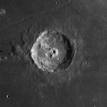
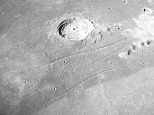
Plinius is a prominent lunar impact crater on the border between Mare Serenitatis to the north and Mare Tranquilitatis to the south. More than 90 km south-southeast is the crater Ross, about 70 km northeast is Dawes and about 70 km WSW is Al-Bakri (or as al-Bakri). Just to the north is a system of rilles named the Rimae Plinius and touching it is the Brackett crater which is more than a crater diameter north. At the northwest edge of the rille is the Promontorium Archerusia, a cape off the western rim that encloses the Mare Serenitatis.
Description
Its diameter is 43 km long and is 4,300 meters deep. The area is between 1,250 and 1,300 km² and the perimeter is about 125 to 130 km.
The sharp rim of Plinius is slightly oval in form, with a terraced inner wall, and an irregular outer rampart. It lacks a visible ray system. The crater floor is hilly, and in the middle is an irregular central peak that has the appearance of a double crater formation under certain angles of illumination. There is a cleft feature attached to the northern side of the peak. The eastern half of the floor is much more smooth and level than the hummocky west, and this section forms a crescent shape about the central peak.
During solar eclipses, especially with long totality, the crater temperature remains high, indicating that their temperature is slightly higher than in the dark mare (basalt plain) of Tranquillitatis and more higher than Haemus. The first was taken in mid-infrared from Earth orbit during a September 1996 lunar eclipse by the Midcourse Space Experiment (MSX) satellite, where it depicted Plinius, seen as a tiny spot.[1]
Names
The crater is named after the Roman writer Pliny the Elder,[2] it was given its name by Giovanni Riccioli, whose 1651 nomenclature system has become standardized.[3][4] Earlier lunar cartographers had given the feature different names. Michael van Langren's 1645 map calls it "Eugeniae" after Isabella Clara Eugenia, queen of the Spanish Netherlands,[3] his map were map slightly apart from the other crater which he called "Schyrlei", now Abenezra[5] And Johannes Hevelius called it "Apollonia" of the ancient world.[3][6]
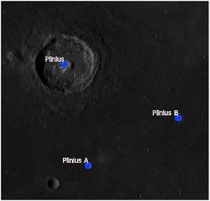
Satellite craters
By convention these features are identified on lunar maps by placing the letter on the side of the crater midpoint that is closest to Plinius.
| Plinius | Latitude | Longitude | Diameter |
|---|---|---|---|
| A | 13.0° N | 24.2° E | 4 km |
| B | 14.1° N | 26.2° E | 5 km |
Plinius A is located about 50 km to the south and Plinuis B located about 70 km to the east-southeast.
In music
The northernmost part of the crater along with its rim (Rimae Plinius) was featured in the photo of the album, Apollo: Atmospheres and Soundtracks (1983), it was displayed on the left of the middle part of the album cover as the north on the album cover is faced to the right.[7]
Notes
- ↑ NASA Astronomy Picture of the Day: Eclipsed Moon in Infrared (8 November 2003)
- ↑ "Plinius". Gazeteer of Planetary Nomenclature. International Astronomical Union. Retrieved 17 August 2017.
- 1 2 3 Ewen A. Whitaker, Mapping and Naming the Moon (Cambridge University Press, 1999).
- ↑ Riccioli map of the Moon (1651)
- ↑ Langrenus map of the Moon (1645)
- ↑ Hevelius map of the Moon (1647)
- ↑ "Apollo: Atmospheres and Soundtracks Review". Allmusic. Retrieved 14 August 2017.
References
- Andersson, L. E.; Whitaker, E. A. (1982). NASA Catalogue of Lunar Nomenclature. NASA RP-1097.
- Blue, Jennifer (July 25, 2007). "Gazetteer of Planetary Nomenclature". USGS. Retrieved 2007-08-05.
- Bussey, B.; Spudis, P. (2004). The Clementine Atlas of the Moon. New York: Cambridge University Press. ISBN 978-0-521-81528-4.
- Cocks, Elijah E.; Cocks, Josiah C. (1995). Who's Who on the Moon: A Biographical Dictionary of Lunar Nomenclature. Tudor Publishers. ISBN 978-0-936389-27-1.
- McDowell, Jonathan (July 15, 2007). "Lunar Nomenclature". Jonathan's Space Report. Retrieved 2007-10-24.
- Menzel, D. H.; Minnaert, M.; Levin, B.; Dollfus, A.; Bell, B. (1971). "Report on Lunar Nomenclature by the Working Group of Commission 17 of the IAU". Space Science Reviews. 12 (2): 136–186. Bibcode:1971SSRv...12..136M. doi:10.1007/BF00171763.
- Moore, Patrick (2001). On the Moon. Sterling Publishing Co. ISBN 978-0-304-35469-6.
- Price, Fred W. (1988). The Moon Observer's Handbook. Cambridge University Press. ISBN 978-0-521-33500-3.
- Rükl, Antonín (1990). Atlas of the Moon. Kalmbach Books. ISBN 978-0-913135-17-4.
- Webb, Rev. T. W. (1962). Celestial Objects for Common Telescopes (6th revised ed.). Dover. ISBN 978-0-486-20917-3.
- Whitaker, Ewen A. (1999). Mapping and Naming the Moon. Cambridge University Press. ISBN 978-0-521-62248-6.
- Wlasuk, Peter T. (2000). Observing the Moon. Springer. ISBN 978-1-85233-193-1.
External links
| Wikimedia Commons has media related to Plinius Crater. |
Other articles
- Wood, Chuck (December 8, 2009). "Edgy". Lunar Photo of the Day. , which include some areas such as Plinius