Rosanna railway station
Rosanna | |||||||||||
|---|---|---|---|---|---|---|---|---|---|---|---|
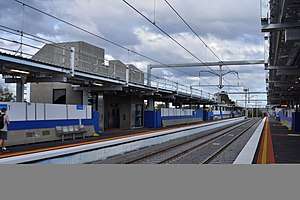 Southbound view in May 2018 | |||||||||||
| Location |
Turnham Avenue, Rosanna Australia | ||||||||||
| Coordinates | 37°44′34″S 145°03′58″E / 37.7429°S 145.0662°ECoordinates: 37°44′34″S 145°03′58″E / 37.7429°S 145.0662°E | ||||||||||
| Owned by | VicTrack | ||||||||||
| Operated by | Metro | ||||||||||
| Line(s) | Hurstbridge | ||||||||||
| Distance | 15.80 kilometres from Southern Cross | ||||||||||
| Platforms | 2 side | ||||||||||
| Tracks | 2 | ||||||||||
| Connections | Bus | ||||||||||
| Construction | |||||||||||
| Structure type | Elevated | ||||||||||
| Parking | 241 | ||||||||||
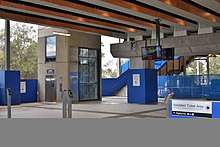
| Disabled access | Yes | ||||||||||
| Other information | |||||||||||
| Status | Unstaffed | ||||||||||
| Station code | ROS | ||||||||||
| Fare zone | Myki zone 2 | ||||||||||
| Website | Public Transport Victoria | ||||||||||
| History | |||||||||||
| Opened | 1 October 1927 | ||||||||||
| Closed | 6 October 2017 | ||||||||||
| Rebuilt | 4 May 2018 | ||||||||||
| Electrified | Yes | ||||||||||
| Services | |||||||||||
| |||||||||||
Rosanna railway station is located on the Hurstbridge line, in Victoria, Australia. It serves the north-eastern Melbourne suburb of Rosanna, and opened on 1 October 1927.[1]
Until May 2018 the line South of Rosanna became single to pass through a short tunnel,this section of track was duplicated in May 2018. Boom barriers were provided at the Lower Plenty Road level crossing in 1972.[2] Three years later, in 1975, the Old station buildings were provided. The Station was Closed on 6 October 2017[3]
On 4 May 2018 a new elevated station was opened by The Level Crossing Removal Authority with the Lower Plenty Road Level Crossing removed.
Platforms & services
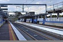
Rosanna has two side platforms. It is serviced by Metro Trains' Hurstbridge line services.[4]
Platform 1:
- Hurstbridge line: all stations and limited stops services to Flinders Street
Platform 2:
- Hurstbridge line: all stations services to Eltham & Hurstbridge
Transport links
Dyson's Bus Services operates two routes via Rosanna station:
References
- ↑ Rosanna Vicsig
- ↑ S0158: Lower Plenty Road Vicsig
- ↑ Vincent Adams Winter (1990). VR and VicRail: 1962-1983. p. 106. ISBN 0-9592069-3-0.
- ↑ Hurstbridge Line timetable Public Transport Victoria
- ↑ Route 513 Eltham - Glenroy timetable Public Transport Victoria
- ↑ Route 517 Northland - St Helena timetable Public Transport Victoria
External links

- Melway map