Rosalia, Kansas
| Rosalia, Kansas | |
|---|---|
| Unincorporated community | |
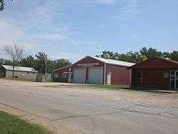 Post office, fire station and a ACA Allertor. (2012) | |
 KDOT map of Butler County (legend) | |
 Rosalia  Rosalia | |
| Coordinates: 37°48′55″N 96°37′11″W / 37.81528°N 96.61972°WCoordinates: 37°48′55″N 96°37′11″W / 37.81528°N 96.61972°W[1] | |
| Country | United States |
| State | Kansas |
| County | Butler |
| Platted | 1883 |
| Area | |
| • Total | 1.3 sq mi (3.3 km2) |
| • Land | 1.3 sq mi (3.3 km2) |
| • Water | 0 sq mi (0 km2) |
| Elevation[1] | 1,519 ft (463 m) |
| Population (2010) | |
| • Total | 171 |
| • Density | 130/sq mi (52/km2) |
| Time zone | UTC-6 (CST) |
| • Summer (DST) | UTC-5 (CDT) |
| ZIP code | 67132 |
| Area code | 620 |
| FIPS code | 20-61100 [1] |
| GNIS feature ID | 474623 [1] |
Rosalia is an unincorporated community in Butler County, Kansas, United States.[1] As of the 2010 census it had a population of 171.[2] It is located approximately 12 miles (19 km) east of El Dorado.
History
Rosalia was platted in 1883. The town was named by its first postmaster for his wife.[3]
In 2014 and 2018, the Symphony In The Flint Hills, an outdoor symphony music event, was held a few miles northeast of Rosalia. In 2014, the attendance was over 7000 people.[4][5]
Geography
Rosalia is located at 37°48′55″N 96°37′11″W / 37.81528°N 96.61972°W (37.8152985, -96.6197416),[1] in the scenic Flint Hills, roughly 12 miles (19 km) east of El Dorado.
Climate
The climate in this area is characterized by hot, humid summers and generally mild to cool winters. According to the Köppen Climate Classification system, Rosalia has a humid subtropical climate, abbreviated "Cfa" on climate maps.[6]
Demographics
Rosalia is designated a Census-Designated Place (CDP) by the United States Census Bureau. As of the 2010 census it had a population of 171.[2]
Government
Rosalia has a post office with ZIP code 67132.[7] The post office was established in 1870.[8]
Education
Rosalia is served by Flinthills USD 492 school district. The Flinthills High School mascot is the Mustangs.[9]
References
- 1 2 3 4 5 6 Geographic Names Information System (GNIS) details for Rosalia, Kansas; United States Geological Survey (USGS); October 13, 1978.
- 1 2 "Geographic Identifiers: 2010 Demographic Profile Data (G001): Rosalia CDP, Kansas". U.S. Census Bureau, American Factfinder. Retrieved November 18, 2013.
- ↑ Mooney, Vol. P. (1916). History of Butler County Kansas. Standard Publishing Company. p. 211.
- ↑ KC Symphony performs in Flint Hills, with plenty of help for the wind section; The Kansas City Star; June 14, 2014.
- ↑ Symphony In The Flint Hills.
- ↑ Climate Summary for Rosalia, Kansas
- ↑ ZIP Code Lookup
- ↑ "Kansas Post Offices, 1828-1961, page 2 (archived)". Kansas Historical Society. Archived from the original on October 9, 2013. Retrieved 5 June 2014.
- ↑ "Rosalia High School". E-YEARBOOK.COM. Retrieved 10 January 2017.
Further reading
External links
- Flinthills USD 492, local school district
- USD 492 School District Boundary Map, KDOT
- Butler County Maps: Current, Historic, KDOT
Municipalities and communities of Butler County, Kansas, United States | ||
|---|---|---|
| Cities | 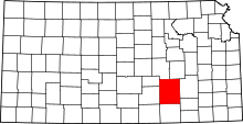 | |
| Unincorporated communities | ||
| Ghost towns | ||
| Townships | ||
| Footnotes | †This populated place is designated a Census-Designated Place (CDP) by the United States Census Bureau, ‡This populated place also has portions in an adjacent county or counties. | |