Brooks Range
| Brooks Range | |
|---|---|
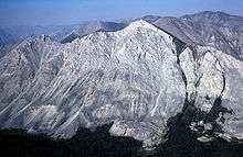
 Brooks Range from near Galbraith Lake | |
| Highest point | |
| Peak | Mount Isto |
| Elevation | 8,976 ft (2,736 m) |
| Coordinates | 69°16′39″N 144°54′40″W / 69.27750°N 144.91111°W |
| Dimensions | |
| Length | 700 mi (1,100 km) East-west |
| Width | 150 mi (240 km) North-south |
| Geography | |
| Countries | United States and Canada |
| States/Provinces | Alaska and Yukon |
| Range coordinates | 68°12′N 152°15′W / 68.200°N 152.250°WCoordinates: 68°12′N 152°15′W / 68.200°N 152.250°W |
| Geology | |
| Orogeny | Laramide |
| Age of rock | Cretaceous |
The Brooks Range (Athabaskan Gwazhał[1]) is a mountain range in far northern North America stretching some 700 miles (1,100 km) from west to east across northern Alaska into Canada's Yukon Territory. Reaching a peak elevation of 8,976 feet (2,736 m) on Mount Isto, the range is believed to be approximately 126 million years old.
In the United States, these mountains are considered an extension of the Rocky Mountains, whereas in Canada they are considered separate, the northern border of the Rocky Mountains regarded as the Liard River far to the south in the province of British Columbia.[2][3]
While the range is mostly uninhabited, the Dalton Highway and Trans-Alaska Pipeline System run through the Atigun Pass (1,415 m, 4,643 ft) on their way to the oil fields at Prudhoe Bay on Alaska's North Slope. The Alaska Native villages of Anaktuvuk and Arctic Village, as well as the very small communities of Coldfoot, Wiseman, Bettles, and Chandalar, are the range's only settlements. In the far west, near the Wulik River in the De Long Mountains is the Red Dog mine, the largest zinc mine in the world.
The range was named by the United States Board on Geographic Names in 1925 after Alfred Hulse Brooks, chief USGS geologist for Alaska from 1903 to 1924.
Various historical records also referred to the range as the Arctic Mountains, Hooper Mountains, Meade Mountains and Meade River Mountains. The Canadian portion of the range is officially called the British Mountains.[4].Ivvavik National Park is located in Canada's British Mountains.
Peaks
- Mount Isto 8,975.1 ft (2,735.6 m)
- Mount Hubley 8,914 ft (2,717 m)
- Mount Chamberlin 8,898.6 ft (2,712.3 m)
- Mount Michelson at 8,855 ft (2,699 m)
- The Gates of Kiev at 7,775 ft (2,370 m), the highest point in the central part of the range, and
- Black Mountain at 5,020 ft (1,530 m), the highest point in the far western part of the range.
- Mount Doonerak 7,457 ft (2,273 m)
- Mount Igikpak 8,276 ft (2,523 m)
- Frigid Crags West Gate 5,501 ft (1,677 m)
- Boreal Mountain East Gate 6,654 ft (2,028 m)
- Limestack Mountain 6,250 ft (1,900 m)
- Cockedhat Mountain 7,410 ft (2,260 m)
Ecology
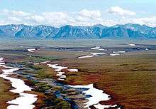
The Brooks Range forms the northernmost drainage divide in North America, separating streams flowing into the Arctic Ocean and the North Pacific. The range roughly delineates the summer position of the Arctic front. It represents the northern extent of the tree line, with little beyond isolated balsam poplar stands occurring north of the continental drainage divide. Trembling aspen and white spruce also occur north of the Brooks Range, though they are limited to sites that have been disturbed by human activity.[5][6] Southern slopes have some cover of black spruce, Picea mariana, marking the northern limit of those trees.[7] As one of the most remote and least-disturbed wildernesses of North America, the mountains are home to Dall sheep, grizzly bears, black bear, gray wolf, moose and porcupine caribou.
In Alaska, the Western Arctic Caribou herd (490,000 strong in 2004) traverses the Brooks Range in its annual migration. The smaller Central Arctic herd (32,000 in 2002), as well as the 123,000 animal Porcupine Caribou herd, likewise migrate through the Brooks range on their annual journeys in and out of the Arctic National Wildlife Refuge. The migration path of the Porcupine Caribou herd is the longest of any terrestrial mammal on earth.
Paleontology
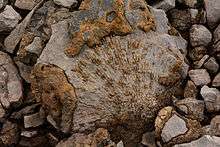
Because the rocks of the range were formed in an ancient seabed, the Brooks Range contains fossils of marine organisms. In addition to the coral fossils shown at left, trilobites and brachiopods from the middle Cambrian have been found in the sandy limestones of the Central Brooks Range.[8]
Climate
While other Alaskan ranges to the south and closer to the coast can receive 250 inches (640 cm) to 500 inches (1,300 cm) of snow, the average snow precipitation on the Brooks Range is reported at 30 inches (76 cm)[9] to 51 inches (130 cm).[10]
As measured at the Anaktuvuk Pass weather station (elevation 770 metres (2,530 ft)), the average summer temperatures are 16 °C (61 °F) as a high and 3 °C (37 °F) as a low. During the winter the average high is −22 °C (−8 °F) while the average low is −30 °C (−22 °F).[10]
Films
- 2007 - Gates of the Arctic: Alaska's Brooks Range
- 2008 - Alone Across Alaska: 1,000 Miles of Wilderness
- 2011 - The Edge of the Earth (short film)
- 2014 - The World Beyond the World (short film)
See also
Notes
- ↑ "GNIS Account Login". geonames.usgs.gov. Retrieved 23 April 2018.
- ↑ The Encyclopedia Americana, Volume 23, page 618 (Grolier 2000).
- ↑ Safire, William. The New York Times guide to essential knowledge: a desk reference for the curious mind, page 623 (Macmillan 2007 ).
- ↑ "Download Geographical Names Data". www.nrcan.gc.ca. Retrieved 23 April 2018.
- ↑ Ackerman, Daniel; Breen, Amy (2016-06-06). "Infrastructure Development Accelerates Range Expansion of Trembling Aspen ( Populus tremuloides , Salicaceae) into the Arctic". ARCTIC. 69 (2): 130–136. doi:10.14430/arctic4560. ISSN 1923-1245.
- ↑ Elsner, Wendy K.; Jorgenson, Janet C. (2009-09-11). "White Spruce Seedling ( Picea glauca ) Discovered North of the Brooks Range Along Alaska's Dalton Highway". ARCTIC. 62 (3): 342–344. doi:10.14430/arctic155. ISSN 1923-1245.
- ↑ C. Michael Hogan, Black Spruce: Picea mariana, GlobalTwitcher.com, ed. Nicklas Stromberg, November, 2008 Archived October 5, 2011, at the Wayback Machine.
- ↑ J.T. Dutro et al, November 1984, "Middle Cambrian Fossils from the Doonerak Anticlinorium, Central Brooks Range, Alaska", Journal of Paleontology Vol. 58 No. 6, pages 1364-1371
- ↑ Shulski, Martha; Wendler, Gerd (2007-12-15). The Climate of Alaska. University of Alaska Press. pp. 148–. ISBN 9781602230071. Retrieved 16 December 2012.
- 1 2 Gallant, Alisa L. (1998-05-01). EcoRegions of Alaska. DIANE Publishing. pp. 15–. ISBN 9780788148965. Retrieved 16 December 2012.
Further reading
- Allan, C. (2013). Arctic citadel : a history of exploration in the Brooks Range region of Northern Alaska. Washington, D.C,: U.S. Department of the Interior, National Park Service.
- Witmer, Dennis "Far to the North: Photographs from the Brooks Range" Far to the North Press (2008) ISBN 0-9771028-0-7
- Kauffmann, John M. "Alaska's Brooks Range: The Ultimate Mountains" (Second Edition) Mountaineers Books (2005) ISBN 1-59485-008-9
- Brown, William E. "History of the Central Brooks Range: Gaunt Beauty, Tenuous Life" University of Alaska Press (2007) ISBN 1-60223-009-9
- Cooper, David "Brooks Range Passage" Mountaineers Books (1983) ISBN 0-89886-061-X
- Dover, J.H., I.L. Tailleur, and J.A. Dumoulin. (2004). Geologic and fossil locality maps of the west-central part of the Howard Pass quadrangle and part of the adjacent Misheguk Mountain quadrangle, Western Brooks Range, Alaska [Miscellaneous Field Studies; Map MF-2413]. Reston, Va.: U.S. Department of the Interior, U.S. Geological Survey.
- Krumhardt, A.P., A.G. Harris, and K.F. Watts. (1996). Lithostratigraphy, microlithofacies, and conodont biostratigraphy and biofacies of the Wahoo Limestone (Carboniferous), eastern Sadlerochit Mountains, northeast Brooks Range, Alaska U.S. Geological Survey Professional Paper 1568. Washington, D.C.: U.S. Department of the Interior, U.S. Geological Survey.
- Marshall, R. (1970). Alaska wilderness; exploring the Central Brooks Range 2nd ed. Berkeley: University of California Press. ISBN 0-520-24498-2
- Mayfield, C.F. et al. (1984). Reconnaissance geologic map of southeastern Misheguk Mountain quadrangle, Alaska [Miscellaneous Investigations Series Map I-1503]. Reston, Va.: U.S. Department of the Interior, U.S. Geological Survey.
- Morin, R.L. (1997). Gravity and magnetic maps of part of the Drenchwater Creek stratiform zinc-lead-silver deposit, Howard Pass quadrangle, northwestern Brooks Range, Alaska [Open-file report 97-705]. Menlo Park, CA: U.S. Department of the Interior, U.S. Geological Survey.
- Morin, R.L. (1997). Gravity models of Abby Creek and Bion barite deposits, Howard Pass quadrangle, northwestern Brooks Range, Alaska [U.S. Geological Survey Open-file Report 97-704]. Menlo Park, CA: U.S. Department of the Interior, U.S. Geological Survey.
- Mull, C.G. et al. (1994). Geologic map of the Killik River quadrangle, Brooks Range, Alaska [U.S. Geological Survey Open-file Report 94-679]. Reston, Va: U.S. Department of the Interior, U.S. Geological Survey.
- Nelson, P.H. et al. (2006). Potential tight gas resources in a frontier province, Jurassic through Tertiary strata beneath the Brooks Range foothills, Arctic Alaska U.S. Geological Survey Open-file Report 2006-1172. Reston, VA: U.S. Department of the Interior, U.S. Geological Survey.
- U.S. Department of the Interior, U.S. Geological Survey. (2003). The natural dispersal of metals to the environment in the Wulik River-Ikalukrok Creek area, western Brooks Range, Alaska U.S. Geological Survey Fact Sheet 107-03. Reston, VA: author.
- U.S. Department of the Interior, U.S. Geological Survey. (1995). Natural environmental effects of silver-lead-zinc deposits in the Brooks Range, Alaska U.S. Geological Survey Fact Sheet 092-95. Reston, VA: author.