Rollesby
| Rollesby | |
|---|---|
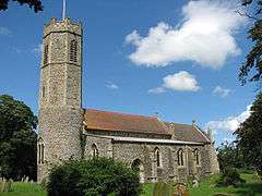 Rollesby St George | |
 Rollesby Rollesby shown within Norfolk | |
| Area | 5.91 km2 (2.28 sq mi) |
| Population | 946 (2011 census)[1] |
| • Density | 160/km2 (410/sq mi) |
| OS grid reference | TG451160 |
| Civil parish |
|
| District | |
| Shire county | |
| Region | |
| Country | England |
| Sovereign state | United Kingdom |
| Post town | GREAT YARMOUTH |
| Postcode district | NR29 |
| Police | Norfolk |
| Fire | Norfolk |
| Ambulance | East of England |
| EU Parliament | East of England |
Rollesby is a village and civil parish in the English county of Norfolk. It is situated on the A149 road, adjacent to Rollesby Broad and Ormesby Broad, about 12 km (7.5 mi) north-west of the town of Great Yarmouth and 30 km (19 mi) east of the city of Norwich.[2]
The civil parish has an area of 5.91 km2 (2.28 sq mi) and in the 2001 census had a population of 995 in 408 households, the population reducing at the 2011 Census to 946.[1] For the purposes of local government, the parish falls within the district of Great Yarmouth.[3]
The church of Rollesby St George is one of 124 existing round-tower churches in Norfolk and is a Grade II* listed building.[4]
Notes
- 1 2 "Civil Parish population 2011". Retrieved 25 August 2015.
- ↑ Ordnance Survey (2005). OS Explorer Map OL40 - The Broads. ISBN 0-319-23769-9.
- ↑ Office for National Statistics & Norfolk County Council (2001). Census population and household counts for unparished urban areas and all parishes Archived 2017-02-11 at the Wayback Machine.. Retrieved December 2, 2005.
- ↑ Historic England. "Church of St George (1152526)". National Heritage List for England. Retrieved 5 March 2014.
External links
![]()
- Map sources for Rollesby.
- Information from Genuki Norfolk on Rollesby.
- Website with photos of Rollesby St George, a round-tower church
This article is issued from
Wikipedia.
The text is licensed under Creative Commons - Attribution - Sharealike.
Additional terms may apply for the media files.