Rokytnice v Orlických horách
| Rokytnice v Orlických horách | |||
| Town | |||
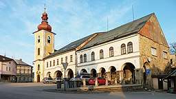 All Saints Church at the T.G. Masaryk Square | |||
|
|||
| Country | Czech Republic | ||
|---|---|---|---|
| Region | Hradec Králové | ||
| District | Rychnov nad Kněžnou | ||
| Commune | Rychnov nad Kněžnou | ||
| Municipality | Rokytnice v Orlických horách | ||
| Elevation | 580 m (1,903 ft) | ||
| Coordinates | 50°10′11″N 16°28′23″E / 50.16972°N 16.47306°ECoordinates: 50°10′11″N 16°28′23″E / 50.16972°N 16.47306°E | ||
| Area | 40.19 km2 (15.52 sq mi) | ||
| Population | 2,378 (2006-08-28) | ||
| Density | 59/km2 (153/sq mi) | ||
| First mentioned | 1318 | ||
| Mayor | Petr Hudousek | ||
| Timezone | CET (UTC+1) | ||
| - summer (DST) | CEST (UTC+2) | ||
| Postal code | 517 61 | ||
  Location in the Czech Republic | |||
| Wikimedia Commons: Rokytnice v Orlických horách | |||
| Statistics: statnisprava.cz | |||
| Website: www | |||

Rokytnice v Orlických horách (Czech pronunciation: [ˈrokɪtɲɪtsɛ ˈvorlɪtskiːɦ ˈɦoraːx]; German: Rokitnitz in Adlergebirge) is a town in the Hradec Králové Region of the Czech Republic. It has around 2,500 inhabitants. The name of the town could be translated literally as "Rokytnice in Orlice Mountains".
Village Nebeská Rybná is an administrative part of Rokytnice v Orlických horách.
Notable people
- Else Kastner-Michalitschke, Austrian writer
External links
- Municipal website (in Czech)

This article is issued from
Wikipedia.
The text is licensed under Creative Commons - Attribution - Sharealike.
Additional terms may apply for the media files.