Rohri
| Rohri روهڙي روہڑی | |
|---|---|
| City | |
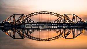 View of the famous British-era Lansdowne Bridge, and Ayub Bridge, which both span the Indus River and offer access between Rohri and Sukkur | |
 Rohri  Rohri | |
| Coordinates: 27°40′59″N 68°54′00″E / 27.68306°N 68.90000°ECoordinates: 27°40′59″N 68°54′00″E / 27.68306°N 68.90000°E | |
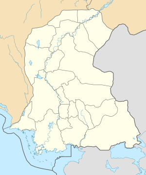
| Country | Pakistan |
| Province | Sindh |
| District | Sukkur |
| Union Councils | 11 |
| Government | |
| • Type | Town Council |
| Area[1] | |
| • Total | 1,319 km2 (509 sq mi) |
| Elevation | 62 m (203 ft) |
| Population (2002)[1] | |
| • Total | 224,362 |
| • Density | 170/km2 (440/sq mi) |
| Time zone | UTC+5 (PST) |
Rohri (Sindhi: روهڙي; Urdu: روہڑی) is a town of Sukkur District, Sindh province, Pakistan. It is located on the east bank of the Indus River, located directly across from Sukkur, the third largest city in Sindh. Rohri town is the administrative headquarters of Rohri Taluka, a tehsil of Sukkur District[2] with which it forms a metropolitan area.
History
Rohri is 10 kilometres (6.2 miles) west of the ancient city of Aror,[3] Little is known about the city's history prior to the Arab invasion in the 8th century,[4] but Aror was the capital of the Ror Dynasty, which was followed by Rai Dynasty and then the Brahman Dynasty that once ruled northern Sindh.
In 711 CE, Aror was captured by the army of Muslim general Muhammad bin Qasim.[5] In 962 CE, a massive earthquake struck the region, causing the course of the Indus River to shift.[6] Aror was re-founded as Rohri afterwards.[7]
Rohri served as a busy port along the Indus by the 1200s, and was a major trading centre for agricultural produce.[7]
Climate
Rohri has a hot desert climate (Köppen climate classification BWh) with extremely hot summers and mild winters. Rohri is very dry, with the little rain it receives mostly falling in the monsoon season from July to September.
| Climate data for Rohri | |||||||||||||
|---|---|---|---|---|---|---|---|---|---|---|---|---|---|
| Month | Jan | Feb | Mar | Apr | May | Jun | Jul | Aug | Sep | Oct | Nov | Dec | Year |
| Record high °C (°F) | 30.6 (87.1) |
37.2 (99) |
42.2 (108) |
47.0 (116.6) |
49.0 (120.2) |
51.0 (123.8) |
47.0 (116.6) |
47.0 (116.6) |
43.3 (109.9) |
43.3 (109.9) |
38.0 (100.4) |
31.1 (88) |
51 (123.8) |
| Average high °C (°F) | 22.8 (73) |
25.3 (77.5) |
31.2 (88.2) |
37.6 (99.7) |
42.4 (108.3) |
43.6 (110.5) |
40.8 (105.4) |
38.7 (101.7) |
38.0 (100.4) |
35.3 (95.5) |
29.9 (85.8) |
24.0 (75.2) |
34.1 (93.4) |
| Daily mean °C (°F) | 15.6 (60.1) |
18.1 (64.6) |
23.8 (74.8) |
29.8 (85.6) |
34.3 (93.7) |
36.0 (96.8) |
34.4 (93.9) |
32.7 (90.9) |
31.4 (88.5) |
27.8 (82) |
22.5 (72.5) |
16.8 (62.2) |
26.9 (80.5) |
| Average low °C (°F) | 8.4 (47.1) |
10.9 (51.6) |
16.4 (61.5) |
22.0 (71.6) |
26.2 (79.2) |
28.4 (83.1) |
27.9 (82.2) |
26.7 (80.1) |
24.9 (76.8) |
20.3 (68.5) |
14.4 (57.9) |
9.6 (49.3) |
19.7 (67.4) |
| Record low °C (°F) | 1.7 (35.1) |
1.0 (33.8) |
5.0 (41) |
10.0 (50) |
16.0 (60.8) |
19.0 (66.2) |
17.5 (63.5) |
17.5 (63.5) |
16.5 (61.7) |
9.5 (49.1) |
5.5 (41.9) |
−1.5 (29.3) |
−1.5 (29.3) |
| Average precipitation mm (inches) | 3.5 (0.138) |
8.0 (0.315) |
5.7 (0.224) |
1.5 (0.059) |
4.0 (0.157) |
4.3 (0.169) |
25.7 (1.012) |
19.8 (0.78) |
10.0 (0.394) |
1.3 (0.051) |
0.6 (0.024) |
3.8 (0.15) |
88.2 (3.473) |
| Source: NOAA (1961-1990) [8] | |||||||||||||
External links
References
- 1 2 "Sukkur's History". Sukkur District Government. Retrieved 2007-11-28.
- ↑ Taluka Municipal Administration Rorhi Archived 2008-10-13 at the Wayback Machine.
- ↑ Nadiem, Ihsan H (2004). Forts of Pakistan. Lahore: Al-Faisal Publishers. p. 54. ISBN 9695033520.
- ↑ Hughes, Albert William (1876). A Gazetteer of the Province of Sind. Retrieved 19 December 2017.
- ↑ Smyth, J W (2005). Sukkur District. Lahore: Sang-e-Meel Publications. pp. 41–43. ISBN 9693517296. This word taken from old word Rohari
- ↑ "Where the city of Aror once stood in glory". Dawn. Retrieved 19 December 2017.
- 1 2 <Bowden, Rob (2004). Settlements of the Indus River. Heinemann-Raintree Library. ISBN 1403457182. Retrieved 19 December 2017.
- ↑ "Rohri Climate Normals 1961-1990". National Oceanic and Atmospheric Administration. Retrieved January 17, 2013.