Rikhawdar
| Rikhawdar ရိခေါ်ဒါရ် | |
|---|---|
| Town | |
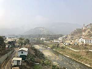 Rihkhawdar on the left and Zokhawthar on the right | |
 Rikhawdar Location in Myanmar | |
| Coordinates: 23°21′55″N 93°23′08″E / 23.3652°N 93.3855°ECoordinates: 23°21′55″N 93°23′08″E / 23.3652°N 93.3855°E | |
| Country |
|
| State | Chin State |
| District | Falam District |
| Township | Tonzang Township |
| Population (2014) | |
| • Town | 6,620[1] |
| • Urban | 3,604 |
| • Rural | 3,016 |
| Languages | |
| Time zone | UTC+5:30 (MST) |
Rikhawdar (Burmese: ရိခေါ်ဒါရ်; also spelt Rihkhuadal or Rihkhawdar), next to Khawmawi, is a border town in Falam District, Chin State, Myanmar.[2] It lies next to Zokhawthar village of the Champhai district of Mizoram, India.[3]
India-Myanmar border
It and Khawmawi form the east side of the border crossing, a bridge across the Harhva river. It is one of the two international border crossings in the Chin State.
References
- ↑ Census Report. The 2014 Myanmar Population and Housing Census. 2. Naypyidaw: Ministry of Immigration and Population. May 2015. p. 52.
- ↑ "Chin State's District Map" (PDF). Myanmar Information Management Unit. 23 October 2017. Retrieved 8 April 2018.
- ↑ "Mizoram villages" (PDF). Land Records Information Systems Division, NIC. Retrieved 2015-08-22.
Capital: Hakha | ||
| Falam District | 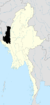 | |
| Hakha District | ||
| Matupi District | ||
| Mindat District | ||
| Cities and towns | ||
This article is issued from
Wikipedia.
The text is licensed under Creative Commons - Attribution - Sharealike.
Additional terms may apply for the media files.