Republican, Arkansas
| Republican, Arkansas | |
|---|---|
| Unincorporated community | |
 Republican  Republican | |
| Coordinates: 35°16′53″N 92°25′31″W / 35.28139°N 92.42528°WCoordinates: 35°16′53″N 92°25′31″W / 35.28139°N 92.42528°W | |
| Country | United States |
| State | Arkansas |
| County | Faulkner |
| Elevation | 374 ft (114 m) |
| Time zone | UTC-6 (Central (CST)) |
| • Summer (DST) | UTC-5 (CDT) |
| Area code(s) | 501 |
| GNIS feature ID | 78166[1] |
Republican is an unincorporated community in Faulkner County, Arkansas, United States. The community is located along local roads in the northeast part of the county, 3.9 miles (6.3 km) northwest of Greenbrier.[2]
The Castleberry-Harrington Historic District and the Farris and Evelyn Langley House, which are listed on the National Register of Historic Places, are both near the community.[3]
References
- ↑ "Republican". Geographic Names Information System. United States Geological Survey.
- ↑ Faulkner County, Arkansas General Highway Map (PDF) (Map). Arkansas State Highway and Transportation Department. September 11, 2014. Retrieved April 9, 2016.
- ↑ National Park Service (2010-07-09). "National Register Information System". National Register of Historic Places. National Park Service.
Municipalities and communities of Faulkner County, Arkansas, United States | ||
|---|---|---|
| Cities | 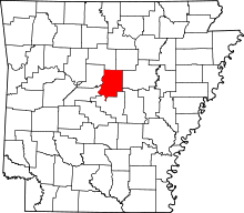 | |
| Towns | ||
| Unincorporated communities | ||
| Footnotes | ‡This populated place also has portions in an adjacent county or counties | |
This article is issued from
Wikipedia.
The text is licensed under Creative Commons - Attribution - Sharealike.
Additional terms may apply for the media files.