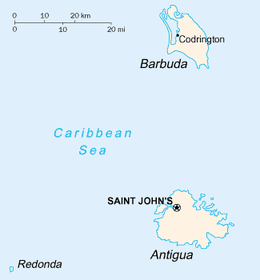
Redonda
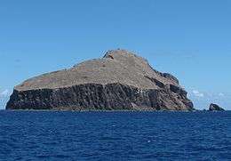 The island of Redonda, viewed from the south | |
 Redonda | |
| Geography | |
|---|---|
| Location | Caribbean Sea |
| Coordinates | 16°56′19″N 62°20′46″W / 16.938646°N 62.346038°WCoordinates: 16°56′19″N 62°20′46″W / 16.938646°N 62.346038°W |
| Archipelago | Leeward Islands, Lesser Antilles |
| Length | 1.6 km (0.99 mi) |
| Width | 0.5 km (0.31 mi) |
| Highest elevation | 296 m (971 ft) |
| Administration | |
| Demographics | |
| Population | Uninhabited |
Redonda is an uninhabited Caribbean island which is legally part of Antigua and Barbuda,[1] in the Leeward Islands, West Indies. The island is about 1.6 kilometres (1 mi) long, 0.5 kilometres (0.3 mi) wide, and is 296 metres (971 ft) high at its highest point.[2]
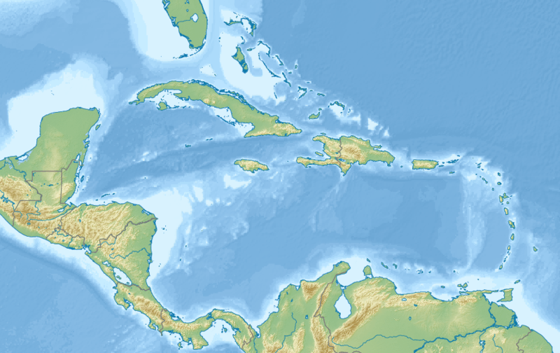
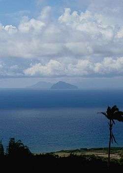
This small island lies between the islands of Nevis and Montserrat, 56.2 kilometres (34.9 mi) southwest of Antigua. Redonda is closer to Montserrat than to any other island; it is located at 22.5 kilometres (14.0 mi) northwest of Montserrat, and 32 kilometres (20 mi) southeast of Nevis.
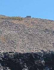
Redonda is home to vast numbers of sea birds, and the island was an important source of guano before artificial fertilizers started to be mass-produced. Guano-mining operations started in the 1860s and ceased after the start of World War I. During these mining operations a few buildings and other installations were put in place on the island, and some physical remnants of that phase in its history are still visible.
The island was named by Columbus in 1493. "Redonda" is the female form of the Spanish language adjective meaning "round".
The island of Redonda became part of Antigua and Barbuda in 1967.
Description
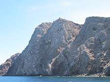
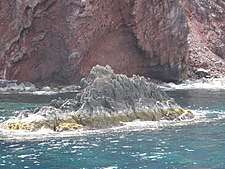
At a distance, Redonda appears as if it were one very large rock. It is the remnant of an ancient extinct volcano. The land rises extremely steeply from sea level, mostly as sheer cliffs, especially on the leeward (west) side of the island. At the top of the island there is an area of grassland that slopes quite steeply to the east. There is no source of fresh water other than rain.
Judging by the name he gave the island, to Columbus the island appeared to be rounded, at least in profile. In reality the island is long and narrow, although it rises steeply to a height of almost 1,000 feet. The actual land area of the island is, however, hard to estimate because of the extreme steepness of the slopes, but it is calculated to be somewhere between 1.6 square kilometres (400 acres) and 2.6 square kilometres (640 acres).
Redonda is uninhabited. The steepness of the surface, the lack of a safe place to land a boat, and the lack of any freshwater source other than rainfall makes the island inhospitable to humans.
Feral goats and rats were removed from the island in 2017[3].
History
Christopher Columbus discovered Redonda in 1493 on his second journey. He claimed it for the Spanish crown, but did not land there. He named the island Santa María de la Redonda, meaning Saint Mary of the Round, reflecting the island's apparent profile when viewed from the side. In the 1860s, the island became a British possession.
During the decades after the 1860s, the rich guano (phosphine oxide) deposits of Redonda were mined for fertiliser, with an annual yield of up to 7,000 tons. Only during this time was the island inhabited, by workers. The population was 120 in 1901. After the guano mining, aluminium phosphate for gunpowder production was discovered and mined. A cableway was constructed to transport material down to the loading pier on the coast.[4]
During the First World War 1914, the mining operations ceased, and most workers left the island. Maintaince workers remained on the island until 1929 when a hurricane destroyed the remainder of the facilities.[4] The island has remained uninhabited since. Two stone huts still stand from the time when the island was occupied. Although the closest island to Redonda is Montserrat, and the second closest is Nevis, Redonda became a dependency of the more distant Antigua, now part of Antigua and Barbuda, in 1967.
Scientists from the Montserrat Volcano Observatory[5] visit the island in a helicopter periodically; they are using Redonda as an observation point from which to take measurements of the Soufrière Hills, an active volcano on Montserrat.
Fauna
Animals endemic to the island include the Redonda ground dragon [6], the Redonda anole [7], and an unnamed species of dwarf gecko[8].
The island is a breeding colony for multiple species of seabirds[9].
Micronation
Redonda is internationally known, in a minor way, as a micronation, because of the curious ongoing myth of the "Kings of Redonda", a story which interweaves fact and fiction. According to a (possibly imaginary) version of events, first recounted decades later by M. P. Shiel, an author of fantasy novels, in the year of his birth, 1865, his father Matthew Dowdy Shiell, from Montserrat, decided to celebrate his first male child by arranging for the boy to be crowned King of Redonda at the age of 15, in a ceremony purportedly carried out on the small island by a bishop.
M. P. Shiel, the son and author, was the first person to ever mention the idea of the "Kingdom of Redonda" and that was in a promotional leaflet for his books. Since then, the title has been "passed down", and continues to the present day. For a period of time the "Royal" lineage of Redonda had a more or less solely literary theme, with the title being given to writers and the like, such as John Gawsworth and Jon Wynne-Tyson. Wynne-Tyson (King Juan II), his successor the Spanish novelist Javier Marias (King Xavier), and rival contenders for the Redondan title, such as Gawsworth, William L. Gates and Bob Williamson, were featured in a BBC Radio 4 documentary, Redonda: The Island with Too Many Kings, which was broadcast in May 2007.[10]
See also
- Rodondo Island, in Bass Strait between Australia and Tasmania, which was named for its resemblance to Redonda
Notes
- ↑ "Government of Antigua and Barbuda". www.ab.gov.ag. Retrieved 11 July 2017.
- ↑ "Antigua and Barbuda: Redonda". www.antiguanice.com. Retrieved 11 July 2017.
- ↑ "Environmental transformation spells brighter future for Redonda's fantastic beasts". Retrieved 2018-08-31.
- 1 2 Kras, Sara Louise (2008). The History of Redonda. Antigua and Barbuda. Cultures of the World. 26. Marshall Cavendish. p. 18. ISBN 9780761425700.
a cableway using baskets was built to transfer the mined phosphate to a pier for shipping
- ↑ "MVO - Montserrat Volcano Observatory". www.mvo.ms. Retrieved 11 July 2017.
- ↑ "Pholidoscelis atratus: Daltry, J.C." IUCN Red List of Threatened Species. 2015-07-22. doi:10.2305/iucn.uk.2017-3.rlts.t50009685a121638486.en. Retrieved 2018-08-31.
- ↑ "Anolis nubilis (Redonda Anole, Redonda Anole)". www.iucnredlist.org. Retrieved 2018-08-31.
- ↑ "Of Rats and Reptiles: An Expedition to Redonda". Anole Annals. 2017-02-21. Retrieved 2018-08-31.
- ↑ "Rare Reptiles Rebound with Radical Restoration of Caribbean Island | Global Wildlife Conservation Global Wildlife Conservation". www.globalwildlife.org. Retrieved 2018-08-31.
- ↑ BBC Radio 4. Redonda: The Island with Too Many Kings, 27 May 2007.
References

External links
| Wikimedia Commons has media related to Redonda. |
| Parishes | ||
|---|---|---|
| Dependencies | ||