Ravansar County
| Ravansar County شهرستان روانسر | |
|---|---|
| County | |
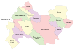
 Counties of Kermanshah Province | |
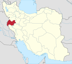
 Location of Kermanshah Province in Iran | |
| Coordinates: 34°45′N 46°41′E / 34.750°N 46.683°ECoordinates: 34°45′N 46°41′E / 34.750°N 46.683°E | |
| Country |
|
| Province | Kermanshah |
| Capital | Ravansar |
| Bakhsh (Districts) | Central District, Shahu District |
| Population (2006) | |
| • Total | 44,983 |
| Time zone | UTC+3:30 (IRST) |
| • Summer (DST) | UTC+4:30 (IRDT) |
| Ravansar County can be found at GEOnet Names Server, at this link, by opening the Advanced Search box, entering "-3801619" in the "Unique Feature Id" form, and clicking on "Search Database". | |
Ravansar county (Persian: شهرستان روانسر) is a county in Kermanshah Province in Iran, part of what is unofficially referred to as Iranian Kurdistan. The capital of the county is Ravansar. It was separated from Javanrud County in 2004. At the 2006 census, the county's population was 44,983, in 10,012 families.[1] The county is subdivided into two districts: the Central District and Shahu District. The county has two cities: Ravansar & Shahu.
This county is bounded in the north to Paveh County and Javanrud County and in the south to Kermanshah County.
Archaeology
Rawansar region has a rich archaeology. Evidence of early human occupation have been found a number of caves around Rawansar such as Mar Koulian and Mar Jawri. The area was important during Iron Age and Achaemenid as can be seen in the rock-cut tomb of Farhad and column bases found around Qoleh rock at north of the town.
References
- ↑ "Census of the Islamic Republic of Iran, 1385 (2006)". Islamic Republic of Iran. Archived from the original (Excel) on 2011-11-11.
- اطلس گیتاشناسی استانهای ایران [Atlas Gitashenasi Ostanhai Iran] (Gitashenasi Province Atlas of Iran)
