Random Formation
| Random Formation Stratigraphic range: Early Cambrian | |
|---|---|
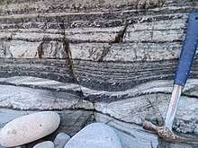
 Some facies of the Random Formation: Synaresis cracks in mudstones, with overlying white cross-bedded tidal sandstones | |
| Type | Formation |
| Unit of | Young's Cove Group,[1] Musgravetown Group,[2] or none,[3] depending on authority (and location) |
| Underlies | (Unconformably) Bonavista Fm and others[4] |
| Overlies |
|
| Thickness | From a few metres to 250 m[6] |
| Lithology | |
| Primary | Herringbone-crossstratified white arenites |
| Other | Grey-green silts and shales |
| Location | |
| Region |
|
| Country |
|
| Type section | |
| Named for | Random Island |
 Bedrock distribution of the Random Formation | |
The Random Formation is a near-shore rock unit dating to the early Cambrian period, dominated by tidal quartz arenites, but also incorporating intertidal and open-shelf deposits, including glauconitic and mud-cracked mudstones (now shales), and red channel sandstones.[4][7] It was deposited quickly and is approximately 175 m thick.[8] The Blue Pinion Formation was originally recognized as a separate formation, but is now interpreted as an expression of the Random Formation.[9][10]
Sedimentology
Its white arenitic sandstones are very distinctive, recognizable from their herringbone cross-stratification that denotes the influence of storm systems. Interbedded green-grey sands and silts speak to an intertidal setting.[5]
Spatial distribution
It is widespread throughout Avalonia - Canada, and Boston, unlike its underlying units. It was deposited in intertidal mud flats / subtidal setting, then (later) near the bottom of an open marine shelf.[11] The top of the unit intergrades with the overlying strata[10]
Stratigraphy
Some maps[1] refer it to the Adeyton group, but strictly it's below this.[5]
It overlies the Chapel Island formation, which contains the Precambrian/Cambrian boundary.[12]
The unit is often strongly folded.[5]
Age

Difficult to date; Some authors slip it in before the Cambrian, by virtue of its lying unconformably underbneath tbe Bonavista formation and conformably above Ediacaran strata.[2]
It does sit (conformably?) above the Chapel Island formation on the Burin peninsula, meaning that at least there its lower boundary is in the Lower Cambrian; and places inarticulate brachiopods have been found in its upper strata, dating these to the late early or even early mid Cambrian.[10]
That said, it is likely that the unit is diachronous, so it may go back into the Ediacaran further east.[10]
On the other hand, the Stage 2 - Stage 3 boundary (Tommotian/Atdabanian) has been supposed to lie within the Random Formation, or possibly in the overlying Bonavista Formation; the Smith Point Formation above that hosts the first trilobites.[13]
Palaeontology
The triolobite-like trace fossils Rusophycus and Cruziana occur in the Random Formation, alongside a range of other ichnofossils including Diplocraterion, Paleodictyon, Scolicia, and Squamodictyon.[13] Body fossils include the small shelly fauna Aldanella attleborensis assemblage.[14]
References
- 1 2 "BEDROCK GEOLOGY OF THE CAPE ST. MARY'S PENINSULA, SOUTHWEST AVALON PENINSULA, NEWFOUNDLAND" (PDF). Retrieved 8 June 2017.
- 1 2 "LATE NEOPROTEROZOIC (EDIACARAN) STRATIGRAPHY OF AVALON ZONE SEDIMENTARY ROCKS, BONAVISTA PENINSULA, NEWFOUNDLAND" (PDF). Retrieved 8 June 2017.
- ↑ Normore (2012). "Current Research". Report 12-1.
- 1 2 S. A. Smith, R. N. Hiscott, Can. J. Earth Sci. 21, 1379–1392 (1987).
- 1 2 3 4 Normore, L. S. 2012: GEOLOGY OF THE RANDOM ISLAND MAP AREA (Nts 2C/04), Newfoundland. Current Research (2012) Newfoundland and Labrador Department of Natural Resources Geological Survey Report 12-:121–145.
- ↑ Hiscott, R. N. 1982: Tidal deposits of the Lower Cambrian Random Formation, eastern Newfoundland; facies and paleoenvironments. Canadian Journal of Earth Sciences 19:2028–2042.
- ↑ Hiscott, Richard N. (1982). "Tidal deposits of the Lower Cambrian Random Formation, eastern Newfoundland: Facies and Paleoenvironments". Canadian Journal of Earth Sciences. 19 (10): 2028. doi:10.1139/e82-180.
- ↑ Crimes, Thomas Peter (1992). "The Record of Trace Fossils across the Proterozoic—Cambrian Boundary". Origin and Early Evolution of the Metazoa. Topics in Geobiology. 10. p. 177. doi:10.1007/978-1-4899-2427-8_6. ISBN 978-1-4899-2429-2.
- ↑ Anderson, M. M. (1981). "The Random Formation of southeastern Newfoundland; a discussion aimed at establishing its age and relationship to bounding formations". American Journal of Science. 281 (6): 807. doi:10.2475/ajs.281.6.807.
- 1 2 3 4 Greene, Bryan; Williams, Harold (1974). "New Fossil Localities and the Base of the Cambrian in Southeastern Newfoundland". Canadian Journal of Earth Sciences. 11 (2): 319. doi:10.1139/e74-027.
- ↑ Smith, S. A., and R. N. Hiscott. 1987: Latest precambrian to Early Cambrian basin evolution, Fortune Bay, Newfoundland fault–bounded basin to platform. Canadian Journal of Earth Sciences 21:1379–1392.
- ↑ Gehling, James G.; Jensen, Sören; Droser, Mary L.; Myrow, Paul M.; Narbonne, GUY M. (2001). "Burrowing below the basal Cambrian GSSP, Fortune Head, Newfoundland". Geological Magazine. 138 (2). doi:10.1017/S001675680100509X.
- 1 2 Peter Crimes, T. (1987). "Trace fossils and correlation of late Precambrian and early Cambrian strata". Geological Magazine. 124 (2): 97–119. doi:10.1017/S0016756800015922.
- ↑ Bengtson, Stefan; Fletcher, Terence P. (1983). "The oldest sequence of skeletal fossils in the Lower Cambrian of southeastern Newfoundland". Canadian Journal of Earth Sciences. 20 (4): 525. Bibcode:1983CaJES..20..525B. doi:10.1139/e83-050.