Raetihi
| Raetihi | |
|---|---|
| Minor urban area | |
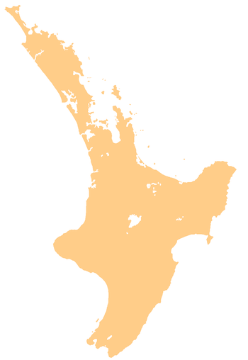 Raetihi Raetihi's location within the North Island | |
| Coordinates: 39°25.5′S 175°17′E / 39.4250°S 175.283°ECoordinates: 39°25.5′S 175°17′E / 39.4250°S 175.283°E | |
| Country | New Zealand |
| Region | Manawatu-Wanganui |
| Territorial authority | Ruapehu District |
| Population (June 2017)[1] | |
| • Total | 1,140 |
| Postcode(s) | 4632 |
.JPG)
Raetihi is a town in the central North Island of New Zealand.[2] It is located at the junction of State Highways 4 and 49, 11 kilometres west of Ohakune. The 2013 New Zealand census recorded its population as 1,002. This constitutes a decrease of 3.2% or 33 people since the 2006 census. 65.3% of residents identified as Māori, 55% European, 2.7% Pacific and 1.2% Asian (some people identified themselves in several ethnic groups and as a result percentages do not add up to 100).[3] The Waimarino district stretches from Mount Ruapehu to the Wanganui River encompassing Raetihi, Pipiriki, Karioi, Horopito, Waiouru, Rangataua and Ohakune. There is evidence of Maori people living here in the fourteenth century. The Ngati Uenuku dwelled at Raetihi and Waimarino (now National Park). There is little evidence of large permanent settlements but hunting parties were common during warmer months.
In 1887 the Government purchased the Waimarino block from the Maori. The first European settlement was at Karioi where sheep were grazed on open tussock land.
The Waimarino block proved to be a “pot of gold”. Between 1908 and 1947 it provided 700 million superficial feet of building timber. The remnants of 150 sawmills have been discovered. Now there are only two major mills operating permanently. One at Tangiwai & one at National Park. In its heyday the sawmilling of rimu, totara, kahikatea, matai and beech trees provided employment for numerous people in the area.
Raetihi (originally called Makotuku due to the river flowing at the towns edge) became the focal point for travellers going between Wanganui and Waiouru. A thriving town emerged to serve the timber workers and those passing through. A trip North from Wanganui was not for the faint-hearted. The scenic “River Road” passing through Pipiriki was treacherous with primitive tracks and long falls if you left the track. Those who completed the journey to Raetihi found hospitality, accommodation, blacksmiths and saddlers for weary horses and supplies for their further travels north.
The great fire of 1918 was a terrible setback to many businesses and homeowners in Raetihi. The loss of numerous mills slowed the timber industry but it continued successfully into the 1940s.
As decades passed, it emerged that the ‘endless’ supply of strong native timber was running out. The choice to replant forests in fast-growing pine was there, but in the middle of the 20th century the ability to treat this new soft wood for outdoor building was not available. Raetihi felt the loss of the timber industry more as each year passed. Farming was an option for some but it would never be as high an employer as the forests once provided.
From the 1970s through to the 1990s, Raetihi fell into a state of depression similar to many rural New Zealand towns. While farming and forestry continue here, it is tourist activities like the 'Mountains to Sea Cycle Trail' and 'Whangani River Adventures' that provides the future for this historic town.
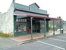
Railway and museum
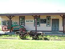
From 18 December 1917 to 1 January 1968, Raetihi was served by the Raetihi Branch, a branch line railway that diverged from the North Island Main Trunk in Ohakune. The station building remains in the town today, relocated from its original site and restored as part of the Waimarino Museum.[4] The museum holds an archive of documents and photographs from the broader Ruapehu area, some of which are available online.[5] It was originally situated on Station Road which lies off to the right over the Makotuku River bridge on the road to Ohakune. The railway reached Raetihi in 1917 and played a vital part in the logging industry. The line was closed to passengers in 1951 and shut completely in 1968 with the decline in tree felling & milling.
The railway station building was moved to its present site on Seddon Street in 1981, seven years after the formation of the museum society. Two more buildings were moved to the museum site in 1983. They are the jail cells & stables. Both were originally by the Makotuku River.
The museum holds documents, photographs and items of daily life showing the progression of the town from its beginnings as a Māori settlement in the 19th century, the arrival of timber mills and large scale logging between 1900 and 1960 and the slow decline of the town following the end of the logging boom to the present.
As is the case throughout New Zealand, the museum is run by volunteers and is open for viewing most weekends and by appointment. A number of archival photographs and documents are available for wider viewing on the museum's website.
History
.jpg)
Although now a small rural town, Raetihi was a minor industrial centre between 1900 and the 1950s. It had numerous timber mills which provided the bulk of employment to the region. As the timber was cleared, agriculture became more prominent in the local economy. The two most prominent agricultural activities are cattle farming and vegetable growing and they now provide the bulk of employment as the timber mills have closed.
The decline of the timber industry negatively impacted upon Raetihi, but it has recently experienced some small growth due to tourism. Its close proximity to Mount Ruapehu and popular ski-fields has led to the establishment of accommodation and cafes to cater for the increasing number of visitors.
Timeline
- 1892 -Raetihi is founded through the government purchase of the Waimarino Block. Until the Main Trunk Line in completed in 1907, Raetihi is accessible mainly via the Whanganui River and horse and dray from Pipiriki.
- 1896 - Raetihi School opens - with a roll of 36. Mr W. Hird, of Nelson is first principal.
- 1900 - Raetihi is the largest centre of the King Country with almost 4,500 people.
- 1903 - co-operative dairy company established.
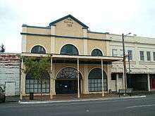
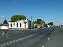
- 1911 - The iconic double-fronted Bank of New Zealand building opens on 17 March under the management of TM Butts, on its current Seddon Street site.
- 1915 - Royal Theatre Opens in lower Seddon Street
- 1917 - Railway branch line reaches Raetihi.
- 1918, 18 March - The 'Great Fire' - about 200 houses were destroyed.[6]
- 1918 - Influenza epidemic.
See also
References
- ↑ "Subnational Population Estimates: At 30 June 2017 (provisional)". Statistics New Zealand. 24 October 2017. Retrieved 24 October 2017. For urban areas, "Subnational population estimates (UA, AU), by age and sex, at 30 June 1996, 2001, 2006-16 (2017 boundary)". Statistics New Zealand. 24 October 2017. Retrieved 24 October 2017.
- ↑ "Place name detail: Raetihi". New Zealand Gazetteer. Land Information New Zealand. Retrieved 29 October 2007.
- ↑ 2013 Census QuickStats about a place:Raetihi
- ↑ David Leitch and Brian Scott, Exploring New Zealand's Ghost Railways, revised edition (Wellington: Grantham House, 1998 [1995]), 27-30.
- ↑ Waimarino Museum, Archival pictures and documents, accessed 29 October 2007.
- ↑ Craig, Dick (1990). The King Country. Waitomo: Waitomo News. pp. 136–137.