Radnor, Indiana
| Radnor | |
|---|---|
| Unincorporated community | |
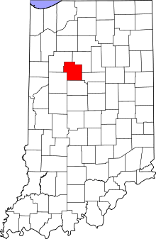 Carroll County's location in Indiana | |
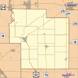 Radnor Location in Carroll County | |
| Coordinates: 40°30′34″N 86°38′06″W / 40.50944°N 86.63500°WCoordinates: 40°30′34″N 86°38′06″W / 40.50944°N 86.63500°W | |
| Country | United States |
| State | Indiana |
| County | Carroll |
| Township | Madison |
| Elevation[1] | 692 ft (211 m) |
| ZIP code | 46923 |
| FIPS code | 18-62694[2] |
| GNIS feature ID | 441727 |
Radnor is an unincorporated community in Madison Township, Carroll County, Indiana. It is part of the Lafayette, Indiana Metropolitan Statistical Area.
History
A post office was established at Radnor in 1883, and remained in operation until it was discontinued in 1975.[3] It may be named after Radnor, Pennsylvania.[4]
Geography
Radnor is located at 40°30′34″N 86°38′06″W / 40.50944°N 86.63500°W.
References
- ↑ "US Board on Geographic Names". United States Geological Survey. 2007-10-25. Retrieved 2008-01-31.
- ↑ "American FactFinder". United States Census Bureau. Retrieved 2008-01-31.
- ↑ "Carroll County". Jim Forte Postal History. Retrieved 28 August 2014.
- ↑ Baker, Ronald L. (October 1995). From Needmore to Prosperity: Hoosier Place Names in Folklore and History. Indiana University Press. p. 275. ISBN 978-0-253-32866-3.
...more likely it is for the county in Wales, perhaps via Pennsylvania.
Municipalities and communities of Carroll County, Indiana, United States | ||
|---|---|---|
| City | ||
| Towns | ||
| Townships | ||
| Unincorporated communities |
| |
This article is issued from
Wikipedia.
The text is licensed under Creative Commons - Attribution - Sharealike.
Additional terms may apply for the media files.