Warberg
| Warberg | ||
|---|---|---|
| ||
 Warberg Location of Warberg within Helmstedt district 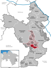  | ||
| Coordinates: 52°11′N 10°56′E / 52.183°N 10.933°ECoordinates: 52°11′N 10°56′E / 52.183°N 10.933°E | ||
| Country | Germany | |
| State | Lower Saxony | |
| District | Helmstedt | |
| Municipal assoc. | Nord-Elm | |
| Government | ||
| • Mayor | Hubert Friehe | |
| Area | ||
| • Total | 8.01 km2 (3.09 sq mi) | |
| Elevation | 132 m (433 ft) | |
| Population (2017-12-31)[1] | ||
| • Total | 818 | |
| • Density | 100/km2 (260/sq mi) | |
| Time zone | CET/CEST (UTC+1/+2) | |
| Postal codes | 38378 | |
| Dialling codes | 05355 | |
| Vehicle registration | HE | |
| Website | www.warberg.de | |

Warberg is a municipality in the district of Helmstedt, in Lower Saxony, Germany.
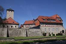
Castle Warberg
References
Towns and municipalities in Helmstedt (district) | ||
|---|---|---|
This article is issued from
Wikipedia.
The text is licensed under Creative Commons - Attribution - Sharealike.
Additional terms may apply for the media files.