La Paz Valley, Arizona
| La Paz Valley, Arizona | |
|---|---|
| Census-designated place | |
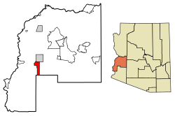 Location of La Paz Valley in La Paz County, Arizona. | |
 La Paz Valley, Arizona Location of La Paz Valley in La Paz County, Arizona. | |
| Coordinates: 33°34′37″N 114°14′31″W / 33.57694°N 114.24194°WCoordinates: 33°34′37″N 114°14′31″W / 33.57694°N 114.24194°W | |
| Country | United States |
| State | Arizona |
| County | La Paz |
| Area[1] | |
| • Total | 29.48 sq mi (76.35 km2) |
| • Land | 29.48 sq mi (76.35 km2) |
| • Water | 0.00 sq mi (0.00 km2) |
| Elevation | 1,027 ft (313 m) |
| Population (2010)[2] | |
| • Total | 52,527 |
| • Estimate (2016)[3] | N/A |
| Time zone | UTC-7 (Mountain (MST)) |
| Area code(s) | 928 |
| GNIS feature ID | 24147[4] |
La Paz Valley is a census-designated place in La Paz County, Arizona, United States. Its population was 699 as of the 2010 census.[2]
Demographics
| Historical population | |||
|---|---|---|---|
| Census | Pop. | %± | |
| U.S. Decennial Census[5] | |||
References
- ↑ "2016 U.S. Gazetteer Files". United States Census Bureau. Retrieved Jul 18, 2017.
- 1 2 "American FactFinder". United States Census Bureau. Retrieved 2011-05-14.
- ↑ "Population and Housing Unit Estimates". Retrieved June 9, 2017.
- ↑ "La Paz Valley". Geographic Names Information System. United States Geological Survey.
- ↑ "Census of Population and Housing". Census.gov. Retrieved June 4, 2016.
Municipalities and communities of La Paz County, Arizona, United States | ||
|---|---|---|
| Towns | 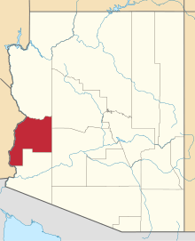 | |
| CDPs | ||
| Populated places | ||
| Indian reservations | ||
| Ghost towns | ||
This article is issued from
Wikipedia.
The text is licensed under Creative Commons - Attribution - Sharealike.
Additional terms may apply for the media files.