Punta Ramiere
| Punta Ramiere | |
|---|---|
| Bric Froid | |
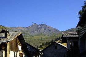 The mountain seen from Le Roux d'Abriès | |
| Highest point | |
| Elevation | 3,302 m (10,833 ft) [1] |
| Prominence | 673 m (2,208 ft) [1][2] |
| Parent peak | Pic de Rochebrune |
| Listing | Alpine mountains above 3000 m |
| Coordinates | 44°52′08″N 06°55′55″E / 44.86889°N 6.93194°ECoordinates: 44°52′08″N 06°55′55″E / 44.86889°N 6.93194°E |
| Geography | |
 Punta Ramiere Alps | |
| Location |
Provence-Alpes-Côte d'Azur, France Piemonte, Italy |
| Parent range | Cottian Alps |
| Climbing | |
| Easiest route | from Colle Ramiere and NW ridge |
The Punta Ramiere (in Italian) or Bric Froid (in French) is a mountain in the Cottian Alps belonging to the department of Hautes-Alpes (FR) and the province of Turin (IT). It's the highest peak of the long stretch of the Po/Rhone water divide starting from the Aiguille de Scolette (north) and ending with the Monviso group (south).
Geography
The Ramiere is the tripoint at which the borders of the Italian comunes of Sauze di Cesana and Cesana and the French commune of Abries meet.
The geodetic point of the Italian Military Geographic Institute named Punta Ramiere (code 066104) is defined on the top of the mountain.[3]
SOIUSA classification
According to SOIUSA (International Standardized Mountain Subdivision of the Alps) the mountain can be classified in the following way:[4]
- main part = Western Alps
- major sector = North Western Alps
- section = Cottian Alps
- subsection = Central Cottian Alps
- supergroup = (It:Catena Bric Froid-Rochebrune-Beal Traversier/Fr:Chaîne Bric Froid-Rochebrune-Beal Traversier )
- group = (It:Gruppo Ramiere-Merciantaira/Fr:Groupe Bric Froid-Grand Glaiza)
- subgroup = (It:Gruppo della Ramiere/Fr:Crête du Bric Froid)
- code = I/A-4.II-B.4.a
Access to the summit
The easiest route for the summit starts from Colle Ramiere (Ramiere pass, 3,007 m) and reaches the mountain top by its northwestern ridge. The pass can be attained by foothpat from the Thuras valley (Cesana Torinese) or the Argentiera valley (Sauze di Cesana).[5]
Nature conservation
The Punta Ramiere is located on the northern border of the French regional nature park of Queyras (Parc naturel régional du Queyras ), established in 1977.[6]
References
- 1 2 Punta Ramière, Italy/France, on www.peakbagger.com (access: May 2012)
- ↑ Key col:Col de Péas 2,629 m
- ↑ Punti geodetici, data on www.igmi.org Archived 2012-06-05 at the Wayback Machine. (accessed in May 2012)
- ↑ Marazzi, Sergio (2005). Atlante Orografico delle Alpi. SOIUSA (in Italian). Priuli & Verlucca. p. 88. ISBN 978-88-8068-273-8.
- ↑ Ferreri, Eugenio (1982). Alpi Cozie centrali. Guida ai monti d'Italia (in Italian). Club Alpino Italiano. p. 373.
- ↑ Histoire, web page on the nature park site www.pnr-queyras.com (accessed in Mayl 2012)
Maps
- Italian official cartography (Istituto Geografico Militare - IGM); on-line version: www.pcn.minambiente.it
- French official cartography (Institut géographique national - IGN); on-line version: www.geoportail.fr
External links
- Punta Ramiere: 360° panoramic image from the summit on pano.ica-net.it