Punta La Entallada Lighthouse
 Punta La Entallada Lighthouse | |
 Canary Islands | |
| Location |
Tuineje Fuerteventura Canary Islands Spain |
|---|---|
| Coordinates | 28°13′49″N 13°56′55″W / 28.230412°N 13.948550°WCoordinates: 28°13′49″N 13°56′55″W / 28.230412°N 13.948550°W |
| Year first constructed | 1955 |
| Construction | rubble masonry tower |
| Tower shape | square tower |
| Height | 12 metres (39 ft) |
| Focal height | 196 metres (643 ft) |
| Range | 21 nautical miles (39 km; 24 mi) |
| Characteristic |
L 0 4 oc 1 2 L 0 4 oc 7 8 L 0 4 oc 7 8 |
| Admiralty number | D2795 |
| NGA number | 24032 |
| ARLHS number | CAI-041 |
| Spain number | ES-12190 |
| Managing agent | Autoridad Portuaria de Las Palmas de Gran Canaria |
Punta La Entallada or La Entallada lighthouse (Spanish: Faro de La Entallada) is an active lighthouse on the Canary island of Fuerteventura. It is located on the east coast, near the village of Las Playitas in Tuineje.[1][2]
History
Completed in 1955, it was constructed by the architect Carlos Alcon who incorporated elements of Moorish architecture in a unique design. Contrasting masonry and white washed mortar has been used to produce a distinctive exterior facade. The coloured stone originating from the village of Tetir, in the centre of the island.[2]
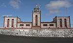
On the seaward face the lighthouse has three square towers, the tallest central tower supporting the lantern dome, which is made entirely of glass. On the landward side the building extends into two arms, with a central courtyard enclosed on three sides by an arched walkway.[2]
Situated on high cliffs provides a focal height of 196m above the sea; the third highest in the Canaries. Its light can be seen for 21 nautical miles, and consists of three flashes of white light every eighteen seconds.[1]
The prominent location means that it is now promoted as a point of interest for tourists, with a viewpoint and car park. The lighthouse is considered to be the closest point in the Canaries to Africa, 100km to the east.[2]
As well as acting as a maritime light, it has also been used historically as an aerial beacon. Aircraft from Gando airfield were directed towards the Spanish Sahara by the lighthouse, including those used in the Ifni conflict.[2]
In 2011, La Entallada in conjunction with five other lighthouses was depicted in a set of six commemorative stamps by Correos the Spanish postal service.[3]
Gallery
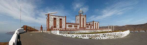
 Front elevation
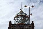 Glass lantern
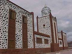 Building details
 View from the Sea
_-_OSM_Mapnik.svg.png)
See also
References
- 1 2 Rowlett, Russ. "Lighthouses of Spain: Canary Islands". The Lighthouse Directory. University of North Carolina at Chapel Hill. Retrieved 5 October 2014.
- 1 2 3 4 5 "La Entallada lighthouse". Museums. artesaniaymuseosdefuerteventura.org. Retrieved 5 October 2014.
- ↑ "Faros 2011". Stamp Issues. Correos. Retrieved 5 October 2014.
External links
| Wikimedia Commons has media related to Faro de la Entallada. |