Puerto del Rosario Lighthouse
.jpg) Lighthouse shown to the right of the power station | |
 Canary Islands | |
| Location |
Puerto del Rosario Fuerteventura Canary Islands Spain |
|---|---|
| Coordinates | 28°30′19″N 13°50′38″W / 28.505378°N 13.843756°WCoordinates: 28°30′19″N 13°50′38″W / 28.505378°N 13.843756°W |
| Year first constructed | 1992 |
| Foundation | cylindrical basement |
| Construction | concrete tower |
| Tower shape | cylindrical tower with double balcony and lantern |
| Markings / pattern | unpainted tower, grey lantern dome |
| Height | 43 metres (141 ft) |
| Focal height | 48 metres (157 ft) |
| Light source | mains power |
| Range | 20 nautical miles (37 km; 23 mi) |
| Characteristic | Fl W 5s. |
| Admiralty number | D2793.5 |
| NGA number | 24034 |
| ARLHS number | CAI-064 |
| Spain number | ES-12165 |
| Managing agent | Autoridad Portuaria de Las Palmas de Gran Canaria[1] |
The Puerto del Rosario Lighthouse (Spanish: Faro de Puerto del Rosario) also known as the Punta Gaviota lighthouse is a modern active lighthouse on the Canary island of Fuerteventura. It is located in an industrial area at the north-eastern end of the town of Puerto del Rosario, the capital and major port of the island in the Province of Las Palmas.[2]
Description
The Puerto del Rosario light is the main navigation marker for the shipping arriving at the port on the eastern side of the island. It lies between the Punta Martiño Lighthouse on the island of Lobos to the north and the Punta La Entallada lighthouse in Tuineje to the south.[3]
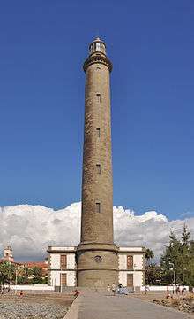
The lighthouse first entered service in 1992, as part of the third maritime lighting plan for the Canaries, other lighthouses that were built as part of the same plan include Punta Lava and Arenas Blancas on La Palma, Punta del Castillete on Gran Canaria and Morro Jable also on Fuerteventura.[4] It consists of a 43m high cylinder-shaped tower, which is white in colour, this supports twin galleries and a lantern with a grey cupola.[2]
The optics include of a 2.25m diameter lens, equipped with a 150 watt discharge lamp, which is connected to mains electricity and a back-up battery system. With a focal height of 48m above sea level, the light can be seen for 20 nautical miles. Its light characteristic is a flash of white light every five seconds. The reserve light has a range of nine nautical miles.[2][5]
The lighthouse is maintained by the Port authority of Las Palmas, and is registered under the international Admiralty number D2793.5 and has the NGA identifier of 113-24034.[2][6]
_-_OSM_Mapnik.svg.png)
See also
References
- ↑ Gaviota (Puerto del Rosario) The Lighthouse Directory. University of North Carolina at Chapel Hill. Retrieved March 30, 2016
- 1 2 3 4 Rowlett, Russ. "Lighthouses of Spain: Canary Islands". The Lighthouse Directory. University of North Carolina at Chapel Hill. Retrieved 2 September 2015.
- ↑ Griffes; National Geospatial-Intelligence Agency (1 October 2009). NGA Sailing Directions-Enroute: 2008 West Coast of Europe and Northwest Africa (11th Edition). ProStar Publications. p. 177. ISBN 978-1-57785-885-0.
- ↑ "Los faros que alumbran et Atlantico" (in Spanish). teldeactualidad.com. Retrieved 2 September 2015.
- ↑ "Faro de Puerto del Rosario". Maritime Signals (in Spanish). Puertos de las Palmas. Retrieved 2 September 2015.
- ↑ List of Lights, Pub. 113: The West Coasts of Europe and Africa, the Mediterranean Sea, Black Sea and Azovskoye More (Sea of Azov) (PDF). List of Lights. United States National Geospatial-Intelligence Agency. 2013. p. 422.