Punta Abona Lighthouse
 Punta Abona Lighthouse (2018) | |
 Canary Islands | |
| Location |
Arico Tenerife Canary Islands Spain |
|---|---|
| Coordinates | 28°08′54″N 16°25′38″W / 28.148358°N 16.427146°WCoordinates: 28°08′54″N 16°25′38″W / 28.148358°N 16.427146°W |
| Year first constructed | 1902 (first) |
| Year first lit | 1976 (current) |
| Deactivated | 1976 (first) |
| Construction |
concrete tower (current) masonry tower (first) |
| Tower shape |
cylindrical tower with double balcony and lantern (current) lantern mounted non the keeper's house roof (first) |
| Markings / pattern |
tower with red and white bands (current) white keeper's house, green lantern roof (first) |
| Height | 39 metres (128 ft) |
| Focal height | 54 metres (177 ft) |
| Range | 17 nautical miles (31 km; 20 mi) |
| Characteristic | Fl (3) W 20s. |
| Admiralty number | D2829 |
| NGA number | 23828 |
| ARLHS number | CAI-022 |
| Spain number | ES-12870 |
| Managing agent | Autoridad Portuaria de Santa Cruz de Tenerife[1] |
The Punta Abona Lighthouse (Spanish: Faro de Punta Abona) is an active lighthouse on the south-eastern coast of Tenerife in the Canary islands. It is located between Abades and Poris de Abona, in the municipality of Arico.[2] The lighthouse was the second to be constructed on the rocky headland of Punta Abona, which marks the south-east side of the island, and lies between the Punta de Anaga lighthouse to the north and the Punta Rasca lighthouse of Arona to the south.[2]
History
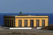
The first lighthouse was completed in 1902, as part of the first maritime lighting plan for the Canaries, to act as a navigation aid for the coastal shipping between Santa Cruz de Tenerife and the ports of the western Canary Islands.[3][4] Built in a similar style to other Canarian 19th century lights, it consists of a white washed single storey building, with dark volcanic rock used for the masonry detailing. This originally contained two separate living quarters, a warehouse, and an office grouped around a small courtyard. The lantern dome was attached to the flat roof of the building, on the seaward side, overlooking the Atlantic Ocean. It remained in service until it was replaced in the 1970s by the new modern tower.[2]
In 2003, the disused structure was partially restored via a two-year programme of training in brick-laying and carpentry for unemployed youths. The aim was to convert the building into an academy for hotel staff, prior to final conversion into a museum and restaurant. These plans now seem to have been delayed or abandoned due to a lack of available investment.[5]
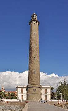
The new lighthouse, which was built next to the original building first entered service in 1976. It consists of a 39m high cylinder-shaped tower, which is white with red bands, that supports twin galleries and a lantern with a black cupola. The design is the same, except fifteen metres higher, than the new tower of Fuencaliente Lighthouse on La Palma.[2] With a focal height of 54m above sea level, the light can be seen for 17 nautical miles. Its light characteristic is made up of three flashes of white light every twenty seconds.[2][4]
The lighthouse is maintained by the port authority of the Province of Santa Cruz de Tenerife. It is registered under the international Admiralty number D2829 and has the NGA identifier of 113-23828.[2][6]
See also
References
- ↑ Abona The Lighthouse Directory. University of North Carolina at Chapel Hill. Retrieved March 28, 2016
- 1 2 3 4 5 6 Rowlett, Russ. "Lighthouses of Spain: Canary Islands". The Lighthouse Directory. University of North Carolina at Chapel Hill. Retrieved 20 May 2015.
- ↑ "Los faros que alumbran et Atlantico" (in Spanish). teldeactualidad.com. Retrieved 2 May 2015.
- 1 2 "2829 Faro de Punta Abona" (in Spanish). Guias masmar. Retrieved 7 July 2015.
- ↑ "Faro Punta Abona sufre deterioro restauracion" (in Spanish). Eldia. 23 June 2014. Retrieved 7 July 2015.
- ↑ List of Lights, Pub. 113: The West Coasts of Europe and Africa, the Mediterranean Sea, Black Sea and Azovskoye More (Sea of Azov) (PDF). List of Lights. United States National Geospatial-Intelligence Agency. 2014. p. 416.
External links
| Wikimedia Commons has media related to Faro de Punta Abona. |