Provo Peak
| Provo Peak | |
|---|---|
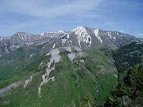 Provo Peak from atop Y Mountain, May 2007 | |
| Highest point | |
| Elevation | 11,068 ft (3,374 m) [1][2] |
| Prominence | 3,442 ft (1,049 m) [3] |
| Coordinates | 40°14′40″N 111°33′24″W / 40.2444014°N 111.5565814°WCoordinates: 40°14′40″N 111°33′24″W / 40.2444014°N 111.5565814°W |
| Geography | |
 Provo Peak Location within the State of Utah | |
| Location |
Provo, Utah United States |
| Parent range | Wasatch Range |
Provo Peak[1] is a mountain peak in the Uinta National Forest in the Wasatch Range that is located within the city limits Provo, Utah, United States.[1][2] The peak has an elevation of 11,068 feet (3,374 m),[1] but a prominence of only 3,442 feet (1,049 m).[3] Although located along the Wasatch Front, it is situated behind (east-southeast) of Y Mountain.[4]
The peak is the namesake of the city of Provo.[5] Near the top of the peak are multiple parallel terraces that can be easily seen from the valley floor from the west or south. These were created in the 1930s to reduce the severe erosion caused by overgrazing on the slopes of the peak.[6]
See also
References
- 1 2 3 4 U.S. Geological Survey Geographic Names Information System: Provo Peak
- 1 2 MyTopo Maps - Provo Peak, Provo, UT, United States (Map). Trimble Navigation, Ltd. Retrieved 12 Dec 2017.
- 1 2 "Provo Peak, Utah". bivouac.com. Retrieved 12 Dec 2017.
- ↑ Google (12 Dec 2017). "Provo Peak" (Map). Google Maps. Google. Retrieved 12 Dec 2017.
- ↑ Kenison, David (8 Aug 2014). "Provo Peak: The city's hidden namesake". Daily Herald. Provo, Utah: Ogden Newspapers. Retrieved 12 Dec 2017.
- ↑ "Provo Peak". geology.byu.edu. Provo, Utah: Brigham Young University: Department of Geological Sciences. Retrieved 12 Dec 2017.
External links

- Provo Peak at peakbagger.com
- Provo Peak at summitpost.com
- Provo Peak at utahhikinginfo.com
This article is issued from
Wikipedia.
The text is licensed under Creative Commons - Attribution - Sharealike.
Additional terms may apply for the media files.