Prodromos, Cyprus
| Prodromos Πρόδρομος | |
|---|---|
| Village | |
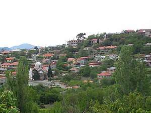 A view of the village in January 2015 | |
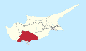
 Prodromos Location in Cyprus | |
| Coordinates: 34°56′54″N 32°49′46″E / 34.94833°N 32.82944°ECoordinates: 34°56′54″N 32°49′46″E / 34.94833°N 32.82944°E | |
| Country |
|
| District | Limassol District |
| Elevation | 1,380 m (4,530 ft) |
| Population (2014) | |
| • Total | 102 |
| Time zone | UTC+2 (EET) |
| • Summer (DST) | UTC+3 (EEST) |
| Postal code | 4840 |
| Website | http://www.prodromos.org.cy/ |
Prodromos (Greek: Πρόδρομος) is the highest village in Cyprus at 1,380 metres (4,530 ft) above sea level. It is the island's main centre for winter sport, with three ski slopes located on nearby Mount Olympus. The village is part of the Limassol District. The number of inhabitants has decreased steadily over the years; by the 2011 census there were only 123 permanent residents, although there are over 240 residences that are temporarily occupied, mostly during the summer and other holidays.[1]
Etymology
Prodromos is named after John the Baptist, who is commonly referred to in Greek Orthodox tradition as 'Prodromos' ('Forerunner' to Christ).
Climate
Prodromos experiences a Mediterranean climate (Köppen: Csa) with warm to hot, dry summers and cool to cold, very wet winters.
| Climate data for Prodromos weather station, elevation: 1380 m (Satellite view) | |||||||||||||
|---|---|---|---|---|---|---|---|---|---|---|---|---|---|
| Month | Jan | Feb | Mar | Apr | May | Jun | Jul | Aug | Sep | Oct | Nov | Dec | Year |
| Mean maximum °C (°F) | 13.3 (55.9) |
13.9 (57) |
18.5 (65.3) |
24.7 (76.5) |
27.9 (82.2) |
30.6 (87.1) |
32.2 (90) |
32.2 (90) |
30.2 (86.4) |
26.6 (79.9) |
20.1 (68.2) |
14.3 (57.7) |
23.7 (74.7) |
| Average high °C (°F) | 6.3 (43.3) |
6.6 (43.9) |
10.3 (50.5) |
15.1 (59.2) |
20.5 (68.9) |
25.0 (77) |
28.1 (82.6) |
27.9 (82.2) |
24.4 (75.9) |
19.6 (67.3) |
12.8 (55) |
8.0 (46.4) |
17.1 (62.8) |
| Daily mean °C (°F) | 3.5 (38.3) |
3.5 (38.3) |
6.6 (43.9) |
10.7 (51.3) |
15.8 (60.4) |
20.1 (68.2) |
23.3 (73.9) |
23.1 (73.6) |
19.6 (67.3) |
15.4 (59.7) |
9.5 (49.1) |
5.3 (41.5) |
13.0 (55.4) |
| Average low °C (°F) | 0.7 (33.3) |
0.3 (32.5) |
2.8 (37) |
6.3 (43.3) |
11.1 (52) |
15.2 (59.4) |
18.4 (65.1) |
18.2 (64.8) |
14.9 (58.8) |
11.3 (52.3) |
6.2 (43.2) |
2.5 (36.5) |
9.0 (48.2) |
| Mean minimum °C (°F) | −4.5 (23.9) |
−5.2 (22.6) |
−2.6 (27.3) |
0.5 (32.9) |
4.7 (40.5) |
9.2 (48.6) |
13.5 (56.3) |
14.0 (57.2) |
10.1 (50.2) |
5.4 (41.7) |
0.1 (32.2) |
−2.8 (27) |
3.5 (38.3) |
| Average precipitation mm (inches) | 133.4 (5.252) |
123.6 (4.866) |
82.3 (3.24) |
56.9 (2.24) |
26.0 (1.024) |
40.0 (1.575) |
12.1 (0.476) |
10.0 (0.394) |
9.5 (0.374) |
24.0 (0.945) |
102.5 (4.035) |
169.7 (6.681) |
790.1 (31.106) |
| Average precipitation days (≥ 1 mm) | 12.4 | 11.2 | 9.8 | 6.7 | 3.7 | 2.1 | 0.7 | 0.7 | 1.4 | 3.5 | 7.4 | 11.2 | 70.7 |
| Mean monthly sunshine hours | 130.2 | 150.8 | 195.3 | 231.0 | 275.9 | 315.0 | 328.6 | 310.0 | 255.0 | 220.1 | 165.0 | 136.4 | 2,713.3 |
| Source: Meteorological Service (Cyprus)[2] | |||||||||||||
References
- ↑ LIVING QUARTERS, HOUSEHOLDS AND POPULATION ENUMERATED BY DISTRICT,MUNICIPALITY/COMMUNITY AND POSTAL CODE (1.10.2011), Cyprus Statistical Service. http://www.cystat.gov.cy/mof/cystat/statistics.nsf/populationcondition_22main_en/populationcondition_22main_en?OpenForm&sub=2&sel=2
- ↑ "Climatological and Meteorological Reports - Prodromos - 1991 - 2005" (PDF). Archived from the original (pdf) on 2016-03-27. Retrieved 2017-06-29.
External links