Pera Pedi
| Pera Pedi Πέρα Πεδί | |
|---|---|
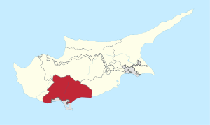
 Pera Pedi Location in Cyprus | |
| Coordinates: 34°51′34″N 32°52′34″E / 34.85944°N 32.87611°ECoordinates: 34°51′34″N 32°52′34″E / 34.85944°N 32.87611°E | |
| Country |
|
| District | Limassol District |
| Population (2001)[1] | |
| • Total | 66 |
| Time zone | UTC+2 (EET) |
| • Summer (DST) | UTC+3 (EEST) |
| Website | http://www.perapedi.org/ wrong link |
Pera Pedi (Greek: Πέρα Πεδί) is a village in the Limassol District of Cyprus, located 4 km south-east of Pano Platres. The E802 road serves the village, and connects to Mandria in the West and Trimiklini in the East. It is the birthplace of president Nicos Anastasiades.
References
This article is issued from
Wikipedia.
The text is licensed under Creative Commons - Attribution - Sharealike.
Additional terms may apply for the media files.