Prim, Arkansas
| Prim, Arkansas | |
|---|---|
| Unincorporated community | |
| Motto(s): Home of the Round Rocks! | |
 Prim, Arkansas  Prim, Arkansas | |
| Coordinates: 35°41′38″N 92°06′31″W / 35.69389°N 92.10861°WCoordinates: 35°41′38″N 92°06′31″W / 35.69389°N 92.10861°W | |
| Country | United States |
| State | Arkansas |
| County | Cleburne |
| Elevation | 1,214 ft (370 m) |
| Time zone | UTC-6 (Central (CST)) |
| • Summer (DST) | UTC-5 (CDT) |
| ZIP code | 72130 |
| Area code(s) | 870 |
| GNIS feature ID | 53799[1] |
Prim is an unincorporated community in Cleburne County, Arkansas, United States. Prim is located at the junction of Arkansas Highway 225 and Arkansas Highway 263, 9 miles (14 km) north-northeast of Greers Ferry. Prim has a post office with ZIP code 72130.[2]
The community has the name of one Mr. Prim, a pioneer citizen.[3]
Education
Public education for elementary and secondary students is provided by West Side School District, West Side Elementary School and West Side High School located in Greers Ferry. The district encompasses more than 147.81 square miles (382.8 km2) of land that includes all or portions of the following communities in Cleburne and Van Buren counties: Edgemont, Greers Ferry, Higden and Prim.[4] There is also a private school, Hilltop Holiness Academy. This is owned and operated by Hilltop Holiness Church.
References
- ↑ U.S. Geological Survey Geographic Names Information System: Prim, Arkansas
- ↑ ZIP Code Lookup
- ↑ Moyer, Armond; Moyer, Winifred (1958). The origins of unusual place-names. Keystone Pub. Associates. p. 106.
- ↑ https://www.westsideeagles.org/documents
Municipalities and communities of Cleburne County, Arkansas, United States | ||
|---|---|---|
| Cities | 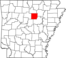 | |
| Towns | ||
| CDP | ||
| Unincorporated communities | ||
| Footnotes | ‡This populated place also has portions in an adjacent county or counties | |