Concord, Arkansas
| Concord, Arkansas | |
|---|---|
| Town | |
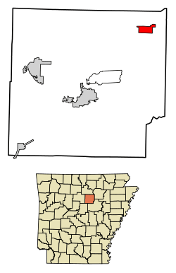 Location of Concord in Cleburne County, Arkansas. | |
| Coordinates: 35°39′51″N 91°50′45″W / 35.66417°N 91.84583°WCoordinates: 35°39′51″N 91°50′45″W / 35.66417°N 91.84583°W | |
| Country | United States |
| State | Arkansas |
| County | Cleburne |
| Area[1] | |
| • Total | 2.87 sq mi (7.43 km2) |
| • Land | 2.86 sq mi (7.42 km2) |
| • Water | 0.00 sq mi (0.01 km2) |
| Elevation | 1,043 ft (318 m) |
| Population (2010) | |
| • Total | 244 |
| • Estimate (2017)[2] | 236 |
| • Density | 82.43/sq mi (31.82/km2) |
| Time zone | UTC-6 (Central (CST)) |
| • Summer (DST) | UTC-5 (CDT) |
| ZIP code | 72523 |
| Area code(s) | 870 |
| FIPS code | 05-15100 |
| GNIS feature ID | 0047951 |
Concord is a town in Cleburne County, Arkansas, United States. The population was 244 at the 2010 census.[3]
Geography
Concord is located near the northeast corner of Cleburne County at 35°39′51″N 91°50′45″W / 35.66417°N 91.84583°W (35.664263, -91.845948).[4] Arkansas Highway 25 passes through the town, leading southwest 22 miles (35 km) to Heber Springs, the county seat, and northeast 18 miles (29 km) to Batesville.
According to the United States Census Bureau, the town of Concord has a total area of 2.8 square miles (7.3 km2), of which 0.004 square miles (0.01 km2), or 0.14%, is water.[3]
Demographics
| Historical population | |||
|---|---|---|---|
| Census | Pop. | %± | |
| 1970 | 163 | — | |
| 1980 | 234 | 43.6% | |
| 1990 | 262 | 12.0% | |
| 2000 | 255 | −2.7% | |
| 2010 | 244 | −4.3% | |
| Est. 2017 | 236 | [2] | −3.3% |
| U.S. Decennial Census[5] 2014 Estimate[6] | |||
As of the census[7] of 2000, there were 255 people, 106 households, and 78 families residing in the town. The population density was 34.8/km² (90.1/mi²). There were 119 housing units at an average density of 16.2/km² (42.1/mi²). The racial makeup of the town was 98.82% White, 0.78% Native American, and 0.39% from two or more races. 1.96% of the population were Hispanic or Latino of any race.
There were 106 households out of which 30.2% had children from family members under the age of 18 living with them, 62.3% were living together, 9.4% had a female householder with no husband present, and 26.4% were non-families. 24.5% of all households were made up of individuals and 14.2% had someone living alone who was 65 years of age or older. The average household size was 2.41 and the average family size was 2.88.
In the town, the population was spread out with 23.1% under the age of 18, 5.5% from 18 to 24, 25.5% from 25 to 44, 27.8% from 45 to 64, and 18.0% who were 65 years of age or older. The median age was 42 years. For every 100 females, there were 102.4 males. For every 100 females age 18 and over, there were 92.2 males.
The median income for a household in the town was $29,844, and the median income for a family was $35,625. Males had a median income of $27,708 versus $8,906 for females. The per capita income for the town was $13,283.13. About 9.3% of families and 13.1% of the population were below the poverty line, including 15.6% of those under the age of 18 and 12.8% of those 65 or over. 78% of the population receive TANF.
Education
Public education of early childhood, elementary and secondary school students is primarily provided by the Concord School District, which leads to graduation from Concord High School. The school mascot is the Pirate with purple and gold serving as the school colors.
References
- ↑ "2017 U.S. Gazetteer Files". United States Census Bureau. Retrieved Aug 22, 2018.
- 1 2 "Population and Housing Unit Estimates". Retrieved March 24, 2018.
- 1 2 "Geographic Identifiers: 2010 Demographic Profile Data (G001): Concord town, Arkansas". U.S. Census Bureau, American Factfinder. Retrieved June 17, 2014.
- ↑ "US Gazetteer files: 2010, 2000, and 1990". United States Census Bureau. 2011-02-12. Retrieved 2011-04-23.
- ↑ "Census of Population and Housing". Census.gov. Archived from the original on May 12, 2015. Retrieved June 4, 2015.
- ↑ "Annual Estimates of the Resident Population for Incorporated Places: April 1, 2010 to July 1, 2014". Retrieved June 4, 2015.
- ↑ "American FactFinder". United States Census Bureau. Archived from the original on 2013-09-11. Retrieved 2008-01-31.
Municipalities and communities of Cleburne County, Arkansas, United States | ||
|---|---|---|
| Cities | 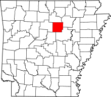 | |
| Towns | ||
| CDP | ||
| Unincorporated communities | ||
| Footnotes | ‡This populated place also has portions in an adjacent county or counties | |