Listed buildings in Little Lever
Little Lever is a village and an unparished area in the Metropolitan Borough of Bolton, Greater Manchester, England. It contains seven listed buildings that are recorded in the National Heritage List for England. All the listed buildings are designated at Grade II, the lowest of the three grades, which is applied to "buildings of national importance and special interest".[1] The Manchester Bolton & Bury Canal, now disused, passes through the area, and four milestones and a post adjacent to it are listed. The other listed buildings are a house, originally serving Ladyshore Colliery, and a church.
Buildings
| Name and location | Photograph | Date | Notes |
|---|---|---|---|
| Ladyshore House 53°33′26″N 2°21′33″W / 53.55710°N 2.35923°W |
— |
1833 | Originally the manager's house, offices and stables for Ladyshore Colliery, later a private house, it is in stone with slate roofs and two storeys. The house has three bays, casement windows, a 20th-century porch, and a doorway with a four-centred arched head, a fanlight and a hood mould. The stable is recessed and has four bays. It has one casement window, the others being mullioned, a doorway with a fanlight, a datestone, and at the rear are lunettes and pitching holes.[2][3] |
| Milestone approximately 60 metres east of Prestolee Road 53°33′17″N 2°22′25″W / 53.55467°N 2.37362°W |
— |
1840s | The milestone is on the towpath of the Manchester Bolton & Bury Canal. It is in stone and consists of a rectangular post inscribed "M/8", indicating the distance in miles from Manchester.[4] |
| Milestone approximately 230 metres north of Prestolee Road 53°33′20″N 2°22′40″W / 53.55561°N 2.37789°W |
— |
1840s | The milestone is on the towpath of the Manchester Bolton & Bury Canal. It is in stone and consists of a rectangular post inscribed "M/81⁄4", indicating the distance in miles from Manchester.[5] |
| Milestone approximately 600 metres southeast of Hall Lane 53°33′29″N 2°22′52″W / 53.55819°N 2.38113°W |
— |
1840s | The milestone is on the towpath of the Manchester Bolton & Bury Canal. It is in stone and consists of a rectangular post inscribed "M/81⁄2", indicating the distance in miles from Manchester.[6] |
| Milestone approximately 220 metres southeast of Hall Lane 53°33′34″N 2°23′10″W / 53.55956°N 2.38614°W |
— |
1840s | The milestone is on the towpath of the Manchester Bolton & Bury Canal. It is in stone and consists of a rectangular post inscribed "M/83⁄4", indicating the distance in miles from Manchester.[7] |
| Post approximately 220 metres southeast of Hall Lane 53°33′35″N 2°23′09″W / 53.55978°N 2.38579°W |
— |
1840s | The post is on the opposite side of the Manchester Bolton & Bury Canal from the milepost. It is in stone and consists of a rectangular post inscribed with the initials of the Lancashire and Yorkshire Railway Company.[8] |
| St Matthew's Church 53°33′46″N 2°22′24″W / 53.56273°N 2.37346°W |
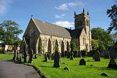 |
1865 | The church was designed by E. G. Paley in early Decorated style, and the tower was raised in height in 1924. It is built in stone with slate] roofs, and consists of a nave, north and south transepts, a west porch, a chancel, a north vestry, and a tower at the southeast corner. The tower has four stages, with a stair turret at the southeast, a plain parapet and corner pinnacles. At the west end are large buttresses, a gabled porch, and a rose window.[2][9] |
References
Citations
Sources
- Historic England, "Ladyshore House, Bolton (1309425)", National Heritage List for England, retrieved 12 June 2017
- Historic England, "Milestone approximately 60 metres east of Prestolee Road, Bolton (1162509)", National Heritage List for England, retrieved 18 June 2017
- Historic England, "Milestone approximately 230 metres north of Prestolee Road, Bolton (1067303)", National Heritage List for England, retrieved 18 June 2017
- Historic England, "Milestone approximately 600 metres southeast of Hall Lane, Bolton (1162519)", National Heritage List for England, retrieved 18 June 2017
- Historic England, "Milestone approximately 220 metres southeast of Hall Lane, Bolton (1067304)", National Heritage List for England, retrieved 18 June 2017
- Historic England, "Post approximately 220 metres southeast of Hall Lane, Bolton (1309598)", National Heritage List for England, retrieved 12 June 2017
- Historic England, "Church of St Matthew, Bolton (1391096)", National Heritage List for England, retrieved 12 June 2017
- Historic England, Listed Buildings, retrieved 18 June 2017
- Hartwell, Clare; Hyde, Matthew; Pevsner, Nikolaus (2004), Lancashire: Manchester and the South-East, The Buildings of England, New Haven and London: Yale University Press, ISBN 0-300-10583-5
This article is issued from
Wikipedia.
The text is licensed under Creative Commons - Attribution - Sharealike.
Additional terms may apply for the media files.