Prüm (river)
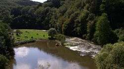
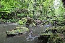
The Prüm (German pronunciation: [ˈpʁʏm]) is a river in Rhineland-Palatinate, Germany, left tributary of the Sauer. Its total length is 95 km, and its basin area is 889 km².[3] The Prüm rises in the Schneifel hills, north of the town of Prüm, close to the border with Belgium. It flows southward through Prüm, Waxweiler, Holsthum, and Irrel. The Prüm discharges to the Sauer in Minden, on the border with Luxembourg, three kilometres east of Echternach. The largest tributary of the Prüm is the Nims.
Catchment and tributaries
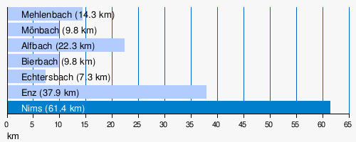
The catchment of the Prüm is 888.758[1] km² in area. Its tributaries include: The largest tributaries of the Prüm are; (l = left bank (dark blue), r = right bank; light blue):
- Mehlenbach (r), 14.3 km, before Watzerath
- Mönbach (r), 9.8 km, after Watzerath
- Alfbach (r), 22.3 km, near Pronsfeld
- Bierbach (r), 9.8 km, after Pronsfeld
- Echtersbach (r), 7.3 km, before Brecht
- Enz (r), 37.9 km, in Holsthum
- Nims (l), 61.4 km, at Irrel
References
- 1 2 3 Geoexplorer of the Rhineland-Palatinate Water Authority (Wasserwirtschaftsverwaltung Rheinland-Pfalz)
- ↑ Combined gauge data from Prümzurlay on the Prüm and Alsdorf-Oberecken on its confluence with the Nims, increased by the remaining catchment area (51.2 km²) with a (low estimate) Mq of 10 l/s km²
- ↑ Geoportal Rheinland-Pfalz
This article is issued from
Wikipedia.
The text is licensed under Creative Commons - Attribution - Sharealike.
Additional terms may apply for the media files.