Irrel
| Irrel | ||
|---|---|---|
| ||
 Irrel Location of Irrel within Eifelkreis Bitburg-Prüm district 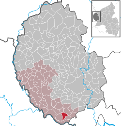 | ||
| Coordinates: 49°50′50″N 06°27′22″E / 49.84722°N 6.45611°ECoordinates: 49°50′50″N 06°27′22″E / 49.84722°N 6.45611°E | ||
| Country | Germany | |
| State | Rhineland-Palatinate | |
| District | Eifelkreis Bitburg-Prüm | |
| Municipal assoc. | Südeifel | |
| Government | ||
| • Mayor | Heinz Haas | |
| Area | ||
| • Total | 7.05 km2 (2.72 sq mi) | |
| Elevation | 170 m (560 ft) | |
| Population (2017-12-31)[1] | ||
| • Total | 1,560 | |
| • Density | 220/km2 (570/sq mi) | |
| Time zone | CET/CEST (UTC+1/+2) | |
| Postal codes | 54666 | |
| Dialling codes | 06525 | |
| Vehicle registration | BIT | |
| Website | Irrel at site www.suedeifelinfo.de | |

Irrel is a municipality in the district Bitburg-Prüm, in Rhineland-Palatinate, Germany. It is situated in the Eifel, near the border with Luxembourg, at the confluence of the rivers Prüm and Nims. It is located approximately 15 km south-west of Bitburg and 5 km north-east of Echternach.
Irrel was the seat of the former Verbandsgemeinde ("collective municipality") Irrel. Since 1 July 2014 it is part of the Verbandsgemeinde Südeifel.[2]
Sights
References
- ↑ Statistisches Landesamt Rheinland-Pfalz "Bevölkerungsstand 2017 - Gemeindeebene" Check
|url=value (help). Statistisches Landesamt Rheinland-Pfalz (in German). 2018. - ↑ "Die Verbandsgemeinde Südeifel" (in German). Verbandsgemeinde Südeifel. July 2014. Retrieved 5 May 2015.
This article is issued from
Wikipedia.
The text is licensed under Creative Commons - Attribution - Sharealike.
Additional terms may apply for the media files.