Porthilly
Coordinates: 50°32′30″N 4°54′47″W / 50.54158°N 4.91312°W

Porthilly (Cornish: Porthhyli) is a small coastal settlement on the east side of the River Camel estuary in Cornwall, England, United Kingdom. It is situated immediately south of the larger village of Rock approximately four miles (6.5 km) northwest of Wadebridge.[1][2]
The settlement is in the civil parish of St Minver Lowlands.[3] It is on the south side of Porthilly Cove, an estuarine bay with a level intertidal beach.[1]
St Michael's church, an ancient chapelry of St Minver parish, stands on the seawall above the cove. First mentioned in a deed dated 1299, the building has Norman features and was substantially restored in 1867. It has a chancel and nave, a south transept and a bell turret containing one bell.[4]
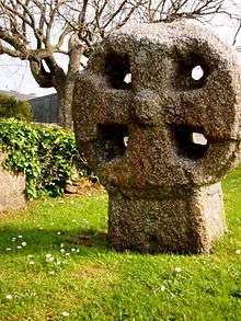
In the churchyard to the south of the church is a medieval four holed cross. It is listed Grade II.[5]
References
- 1 2 Ordnance Survey: Explorer map (scale 1:25000); Sheet 106 Newquay & Padstow ISBN 978-0-319-24016-8
- ↑ Ordnance Survey: Landranger map sheet 200 Newquay & Bodmin ISBN 978-0-319-22938-5
- ↑ "Archived copy". Archived from the original on 2013-09-27. Retrieved 2010-05-01. Cornwall Council online mapping. Retrieved June 2010
- ↑ GENUKI website; St Minver. Retrieved June 2010
- ↑ Historic England. "Churchyard Cross in St Michael's Churchyard, Porthilly (1014624)". National Heritage List for England. Retrieved 21 June 2017.
Cornwall Portal | |
| Unitary authorities | |
| Major settlements |
|
| Rivers | |
| Topics | |