Ponta de Água
| Ponta de Água | |
|---|---|
| Neighbourhood | |
| Coordinates: 14°56′06″N 23°30′29″W / 14.935°N 23.508°WCoordinates: 14°56′06″N 23°30′29″W / 14.935°N 23.508°W | |
| Country | Cape Verde |
| Island | Santiago Island |
| City | Praia |
| Population (2010) | 8,682 |
| Postal code | 7601 |
| Website | www.cmpraia.cv |
Ponta de Água is a subdivision of the city of Praia in the island of Santiago, Cape Verde. Its population was 8,682 at the 2010 census.[1] It is situated 2 km north of the city centre. Adjacent neighbourhoods are Monteagarro to the north, Coqueiro/Castelão to the east, Lem Cachorro to the south, Vila Nova to the southwest and Safende to the west.
References
- ↑ "2010 Census results Santiago". Instituto Nacional de Estatística Cabo Verde (in Portuguese). 24 November 2016.
| Neighbourhoods |  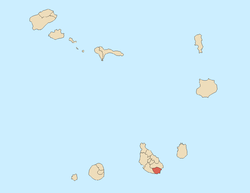 | |
|---|---|---|
| Geographical features | ||
| Education | ||
| Landmarks | ||
| Culture | ||
| Sports | ||
| Transportation | ||
| Media | ||
| History | ||
This article is issued from
Wikipedia.
The text is licensed under Creative Commons - Attribution - Sharealike.
Additional terms may apply for the media files.