Pokonji Dol
 | |
| Geography | |
|---|---|
| Coordinates | 43°09′24″N 16°27′10″E / 43.15667°N 16.45278°ECoordinates: 43°09′24″N 16°27′10″E / 43.15667°N 16.45278°E |
| Archipelago | Paklinski Islands |
| Area | 0.017 km2 (0.0066 sq mi) |
| Length | 0.170 km (0.1056 mi) |
| Width | 0.140 km (0.087 mi) |
| Coastline | 0.47 km (0.292 mi) |
| Highest elevation | 11 m (36 ft) |
| Administration | |
| County | Split-Dalmatia County |
|
| |
 Location in Croatia | |
| Location |
Croatia |
|---|---|
| Coordinates | 43°09′24″N 16°27′10″E / 43.15655°N 16.45265°E |
| Year first constructed | 1872 |
| Tower shape | square tower with balcony and lantern centred on the roof of the two-story keeper’s house |
| Markings / pattern | unpainted stone |
| Height | 15 feet (4.6 m) |
| Focal height | 20 feet (6.1 m) |
| Range |
main: 10 nautical miles (19 km; 12 mi) reserve: 5 nautical miles (9.3 km; 5.8 mi) |
| Characteristic | W Fl 4s |
| Admiralty number | E3410 |
| NGA number | 13612 |
| ARLHS number | CRO-119[1] |
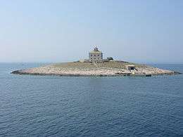
Pokonji Dol is an islet in the Croatian part of the Adriatic Sea, which is situated 500 meters south from Hvar. Pokonji Dol is one of the Paklinski islands. The lighthouse in the middle of the islet was built in 1872.[2] Because Pokonji Dol is the eastern-most island of the Paklinski otoci (Hell Islands) archipelago, the lighthouse ensures the safe navigation of vessels coming from the open sea.
See also
References
- ↑ Lighthouses Directory
- ↑ "Pokonji Dol". Lighthouses. Plovput. Retrieved 10 February 2015.
External links

This article is issued from
Wikipedia.
The text is licensed under Creative Commons - Attribution - Sharealike.
Additional terms may apply for the media files.